
The Puerto Natales airport opened (eventually) just for us,

View of Paine from the air.
 Funny translations abounded.
My friend Erik on our first ascent into the Fitzroy area.
 Fitzroy
shrouded by clouds. Can see Glaciar Piedras Blancas (blue ice) at
right.
Fitzroy
shrouded by clouds. Can see Glaciar Piedras Blancas (blue ice) at
right.  Typical bridge.
 Glaciar (and Laguna) Piedra Blancas. Note iceberg.
 Another view of cloud-shrouded Fitzroy.
End of Day 1 in Fitzroy after 8.5 hours of trail run/walking.
 Day 2: Cerro Torre.
Cerro Torre above Laguna Torre.
 Fitzroy above Lago Madre.
 Fitzroy above Laguna de los Tres.
 Continuation of panorama.
 Looking down on Lago Madre while descending from Laguna de los Tres.
A happy Erik after an epic day 2: 7.25 hours of trail running, the vast majority really running.

Ditto for me.
 Main street of El Chalten, the base for Fitzroy running.
 Midpoint
of bus ride from Chalten to Calafate. The glacier-melt river is a
beautiful color, not captured here, and is constantly roiling as it
makes its way through the desert to the Atlantic 140 miles away.
Midpoint
of bus ride from Chalten to Calafate. The glacier-melt river is a
beautiful color, not captured here, and is constantly roiling as it
makes its way through the desert to the Atlantic 140 miles away.
Pet guanaco---the bus didn't stop to take pictures of the many wild ones.

Lago Argentino on the outskirts of Calafate.
 Inside the plane.
 The plane ride was a highlight of the trip.
Wild nandu (ostrich-like bird). Look hard---it blends in well.

Day 0 in Paine; Rio Ascensio. Note smoke from brushfire---normally you'd see big mountains back there!.

Rave run.
 Day 1 in Paine: between Rio Ascensio and Albergue Los Cuernos.
Ditto.

Ditto. The river empties into Lago Nordenskjold.

Lago Nordenskjold.
 Glaciar Frances.
Torrential stream in Valle Frances.

Ditto.

Awesome view of Glaciar Frances. Every 10 minutes or so, you can see an avalanche somewhere in the valley.
 Backside
of the Cuernos del Paine.
Backside
of the Cuernos del Paine.
Ditto.

More typical view of the Cuernos, from near Refugio Pehoe.

Ditto.
 Day 2 in
Paine: A hanging lake (perched just above Lago Grey, whose valley is
in the background).
Day 2 in
Paine: A hanging lake (perched just above Lago Grey, whose valley is
in the background).
Ditto.

Lago Grey. Note icebergs.

First view of Glaciar Grey emptying into Lago Grey. It's immense: we are about 300 m above Lago Grey, and Glaciar Grey attaches to the Southern Patagonian ice field which extends about 200km further back!
 Getting closer to Glaciar Grey...
...and closer...

...and closer.

Trail is now directly above Glaciar Grey (and steep!).


View of Glaciar Grey from viewpoint close to Refugio Grey. Ominous sounds are heard every 5-10 minutes as the ice blocks shift.

Day 3 in Paine: Start of trek on Glaciar Grey.

Some of the ice is very blue!

Pools (and rivers and waterfalls) abound in the lower reaches of the glacier, which are melting.

Ice climbing on Glaciar Grey.
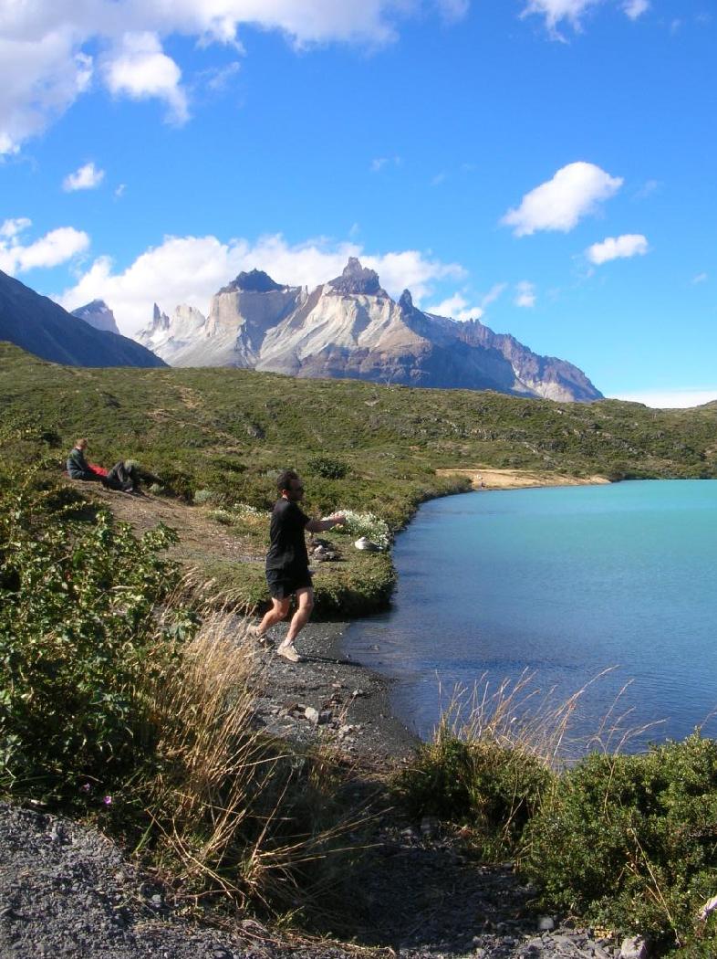
Skipping rocks on Lago Pehoe, in view of the Cuernos.
 Above
Lago Pehoe.
Above
Lago Pehoe.
Day 4 in Paine: Combination of smoke and rain blowing through the Cuernos. On the boat we are told to evacuate as high winds have fanned the fire.

The fire almost reached our evacuation route.
 Post-evacuation day: Araucaria tree in Fuerte Bulnes.

Ditto.

Seal near Fuerto Bulnes.
 Post-evacuation day in Santiago: the cathedral.
Cerro Santa Lucia, downtown Santiago.
 Presidential palace, Santiago.