- Overview
- Training
- Preparation: Guides, Maps, Camera
- Day Zero: Santiago
- Day One: Santiago to Puerto Natales
- Day Two: Puerto Natales to El Chalten
- Day Three: Finally Trailrunning!
- Day Four: Epic Day of Trailrunning!
- Day Five: Chalten to Calafate
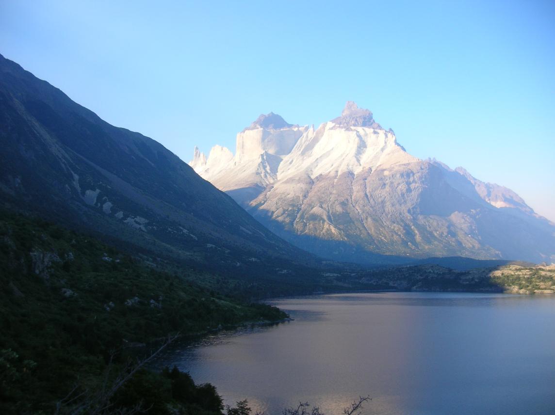
- Day Six: Calafate to Parque Nacional Torres del Paine
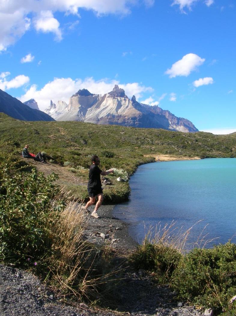
- Day Seven: Epic Run from Refugio Las Torres to Refugio Pehoe, with Sidetrip up Valle Frances
- Refugio Pehoe
- Day Eight: "Easy" Day to Refugio Grey
- Refugio Grey
- Day Nine: Glacier Trek and Easy Run Back to R. Pehoe
- More Thoughts on Refugio Pehoe
- Day Ten: Evacuation!
- Leaving Chile
Overview
We had a base in Santiago and started planning an out-and-back to Torres del Paine. Later we decided we could squeeze in an extra side trip to the Fitzroy area in Argentina. We didn't realize at first that Calafate, the nearest airport to the Fitzroy area, was served by jets from Buenos Aires. Had we planned better, maybe a circle like Santiago-Buenos Aires-Calafate-Natales (nearest city to Torres del Paine)-Punta Arenas-Santiago would have been a good option.If you are planning a trip, I will assume you have already read about my 1998 trip. Rather than update that page, I'll just write here about what was new and different. I covered a lot more ground on the 2005 trip, so there is a lot that is new and different.
Training
We had only a month to train. Erik and I are astronomers who were going to Cerro Tololo in Chile to observe. The trailrunning addition to this trip came only a month before we were to leave, when my wife and I decided the dates of the Chile trip (set by the observatory for the second week of February and unchangeable) made it just too complicated for me to join her on a long-planned visit to her family in Brazil. So she gave me the wonderful gift of encouraging me to use that time for a trailrunning trip free of family constraints. However, she insisted that I not go alone, for safety reasons. Luckily Erik is also a trailrunner and needed little encouragement!So by the time we had settled this, it was early January and had only a month. I was coming off a decent (flat, sea-level) marathon on Dec. 5, but this was still a far cry from running all day in mountains with a backpack. I was just starting to run trails and mountains. Erik was even more courageous, being on the comeback from a long time off due to injury. He broke every rule in the book to build up fast enough (he had done one marathon the previous year, so he had some experience). As the trip started, he admitted that he hadn't told me about all the stresses on his body during the training period, for fear that I would scale back the trip for safety. So then I felt free to tell him that I had been doing the same!
We spent the first few weeks building up our stamina without yet thinking about backpacks. We weren't yet committed to running the Paine circuit, so maybe big packs wouldn't be necessary. (The Paine Circuit is a roughly 60-mile loop around Chile's most famous national park, with a 1000-meter climb at the most remote point. Most people hike it in a week or so, but we were thinking of running it.)
We built up to a big weekend in which we did a three-hour trail run in the Auburn area (lower Sierra Nevada) on Saturday, then a five-hour, quadruple Cold Canyon on Sunday. Cold Canyon is a 4.5 mile loop in the Vaca Mountains with a brutal 1000-foot ascent in the first mile. Neither of these runs was at high altitude, but that was ok because the highest point on the Paine circuit is less than 4000 feet.
Next, we started thinking about running with packs as we grew more committed to running the circuit. So one day I set out with my regular day pack with about 15 pounds in it. I was planning on six miles or so, to gradually build up my tolerance to packs, but at the turnaround point I felt good so I pushed on. Big mistake. I started getting a blister on my lower back due to pack rub, and found myself still four miles from home. This blister didn't let me run with a pack for the next week. By that time, we had realized that we needed frame packs, both for the advantages of the frame and because we couldn't fit everything we needed in a day pack. (Another, unexpected advantage was that air could around my back and prevent too much sweat buildup.) So I had time to do just one 6-miler with all my stuff (30 pounds) in a frame pack before leaving for Chile. We were taking a big risk because, to do the circuit hut-to-hut and avoid carrying a tent, we had to do a marathon the first day in Paine and a marathon the next day too!
Preparation: Guides, Maps, Camera
I used Lonely Planet's book Trekking in Patagonia and found it just fine for choosing and finding the hikes and even navigating during the hikes. The only complaint I have is that it lists very few places to stay and things to do in the gateway cities, so that we found ourselves wishing we had also brought Lonely Planet's guide to Chile, which does have that kind of thing. But two books would have been too much to carry.You needn't worry about buying detailed maps if you are doing the more popular hikes. Trekking in Patagonia certainly had detailed enough maps and descriptions of the treks to avoid getting lost. Also, upon entering Paine and paying the $10000 entrance fee, you get a very nice map which also has elevation profiles of the various treks. All the trails we went on were very well marked. But if you are doing less popular treks, you may need to buy maps.
I took a compass because my wife made me, but it's not really necessary for FitzRoy and Paine, which contain enough easily recognized landmarks and have very well-marked trails. Still, it would come in handy if you got lost in a fog, so just make sure you buy one balanced for the southern hemisphere. You can buy an expensive universal one before you leave, but it is much cheaper (US$7 instead of US$70) to buy a simple one in Chile.
I bought a new digital camera just for the trip. My wife's camera (intended more for serious photography) was too big and heavy (and expensive) for such a trip. I got a lightweight one which uses regular, easily replaceable batteries, and I never regretted it.
Day Zero: Santiago
We arrived in Santiago after a week at the observatory. Erik and I had met a colleague named Reiko at the observatory, after knowing her only through email beforehand. The three of us got along well together, which is not always easy through a week of staying up nights and trying to sleep days. Erik and I even took Reiko for short runs around the mountain. So Reiko changed her flight on the way back to stay with us one night in Santiago.We all went for a quick 1-hour run along the river. My legs were still sluggish from an epic run I had taken the previous morning between observing and sleeping.
After dinner, I realized that I had to deal with something I had been hiding. Since the flight down from North America a week before, I knew that the blister on my lower back (from that stupid long run with the daypack) was infected. I had been hoping that it would get better by itself, but now the hard reality of the flight south the next morning set in. I had to ask Erik and Reiko to drain it. It was the one place on my body where I couldn't drain it myself. It was not as bad as I had imagined, with Erik making jokes about this not being in his job description, and me relaxing somewhat in the knowledge that two people were finally looking at this thing and they were not saying that I should cancel the trip. I slept a little better that night.
Day One: Santiago to Puerto Natales
We flew LAN to Punta Arenas (airport code: PUQ), which is the only way to fly from Santiago (one quick stop in Puerto Montt; 4.5 hours; US$300 or so). If you sit on the port side of the plane, you get great views of the volcanos in the Lake District, and on a good day, great views of Fitzroy and Paine.There are several bus companies which will take you from Punta Arenas to Puerto Natales (3 hours). Buses Fernandez has the most daily departures, so you might want to check them first. Note that they are not at the address given in Lonely Planet's Trekking in Patagonia book; ask around for the correct location (on Colon, but I forgot the cross street).
We stayed at a modest place in Natales. Here and in Punta Arenas on the way back, we did not make any advance plans for lodging, but looked around a bit after arriving. Places with vacancies send people to greet travellers getting off the bus, so if a bed is all you're looking for, this is a nice flexible way to go. If you care about amenities like 24-hour hot water and really clean bathrooms, you may decide to look around a bit more after seeing the place they take you to. Consult a Chile guide book to get lodging advice in advance. Our trekking guide was NOT good for this purpose. It listed just a few places to stay in each city. Plan ahead, and carry guidebooks, in direct proportion to your desire for good lodging. For us (two men), it was ok to take the risk of a mediocre place in return for the flexibility of not having to plan ahead for every night.
Day Two: Puerto Natales to El Chalten
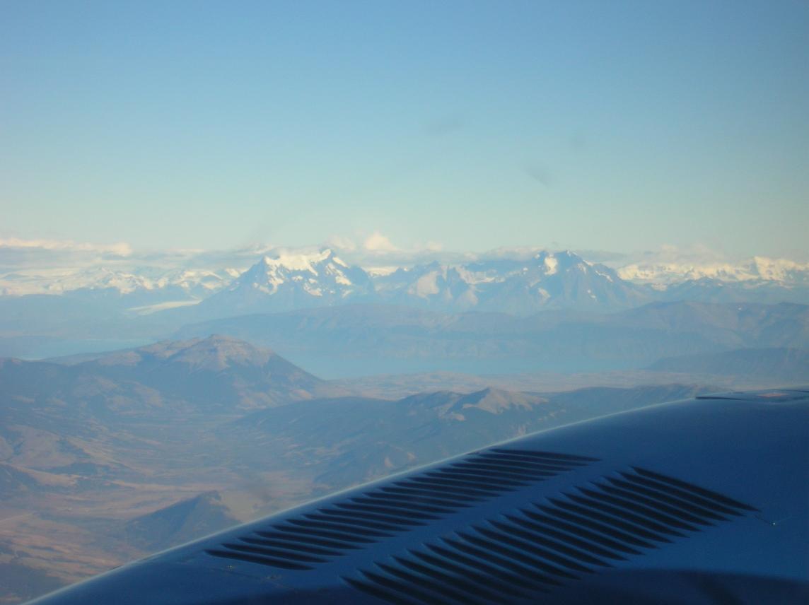
The next day, we started our four-day side trip before entering Paine. We flew a tiny airline called Aerovias DAP from Puerto Natales to El Calafate in Argentina (Monday through Friday, 9am, 1 hour flight). Most people take the 5-hour bus ride and haven't even heard of this option. My advice: take it while you can get it. It's only US$50, you get great views, it saves 5 hours on a bus (which itself costs $10000 or US$20), and it's the most adorable little plane ride you will ever take. I knew in advance that the plane had room for 7 passengers, so I expected a small operation, but it was much cuter than I expected. They told us to show up at the airport 15 minutes before departure time! I was extremely conservative and showed up one hour before departure. The airport was locked. Thirty minutes before departure, the control tower guy showed up and let us in. Eventually eight employees were there just for us two passengers: two people to check us in, baggage handler, two pilots, two control tower people, and an immigration officer to stamp our passports. And they were all very nice. But I don't see how they can stay in business at that price and with so few passengers. Especially in high season!
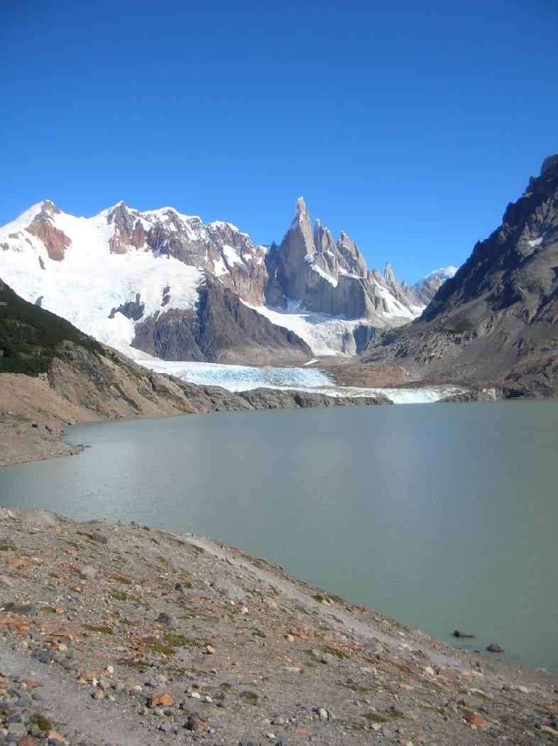
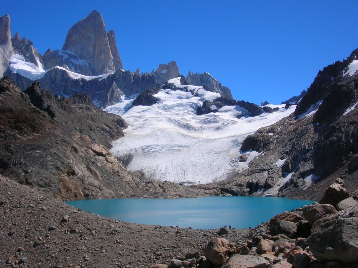
Here is the view of Paine we got from the plane:
If you do fly, keep in mind that there is a 10 kg weight limit on the
baggage. Our backpacks were 11 and 13 kg respectively, and they let
it pass. But on the return trip from Calafate to Natales, there was a
couple that had real luggage (more like tourists than trekkers) and
had to buy an extra ticket for it (but at that price, who cares?).
They don't say anything about the 10 kg limit on their website; only
when you pick up the ticket (which, for us, was when we showed up at
the airport) do you get a notice. Also, note that Trekking in
Patagonia gives the wrong phone number for Aerovias DAP in
Natales. Call their Punta Arenas number and get the correct number
for Natales. Finally, note that air travel is made more expensive by
the habit of placing airports 20 or 25 km outside the town, no matter
how small the town is. The taxi bill can be a significant fraction of
the flight! This happened in both Puerto Natales and Calafate.
As soon as we stepped outside the Calafate airport, the biting flies attacked us. So I took an immediate dislike to Calafate. We hung around the airport for about an hour to catch a bus into town. The buses show up only when a flight arrives from Buenos Aires, not for the puddle jumper from Natales.
Next, we had to arrange a nominally 4.5 hour bus ride over unpaved roads to Chalten. We arrived at the Calafate bus station before noon, but found that the first departure for Chalten was at 6pm! We asked at every bus company, and they all left at 6, 6:30, or 7. This was a general rule, that efforts to save time were unrewarded. Relax and go with the flow. However, I found it difficult to follow this advice. I had to go to the bathroom several times in the bus station (typical traveller problem) and I encountered just a few minor obstacles: Of the four stalls, only one (ONE!) actually had a seat on the toilet! Next, there was NO soap OR towels to wash or dry hands. Luckily I did have some soap and a towel in my backpack, but it was a huge pain to dig them out, and it was also annoying that I had to use some of my small supply of soap, and store a wet towel in my backpack. Strange that the Calafate airport is gleaming and efficient, but the bus station should be so pathetic.
So we had a few hours to kill. Good thing, because our reservation in Chalten had never been confirmed, and we would be arriving after dark. Erik had requested a room in the FitzRoy Inn through CHIP (the Chile Information Project, which ostensibly makes it easier for you to reserve rooms by going through an English-language website), but they had never really gotten back to him. (Turns out the web request goes not to a database, but to a person in Chile who may or may not ensure that the hotel follows through.) So I called the FitzRoy Inn and they said they had no reservation under his name. So I called the next place listed in our guidebook. Full. Next: full. Next: full. Nothing else in our guidebook. So we searched the web. The tiny city of El Chalten actually has a decent website , with all the lodging listed and described in some detail. I had to call about 10 places before we found one with a vacancy, and that only for one night rather than three. We decided to deal with that the next day. All we wanted was to arrive in Chalten at 10:30 pm knowing we had a room.
In the remaining time, we decided to arrange a place to stay in Calafate on the way back, looking at places in person. We found a decent place with a very helpful owner, the Hostal Almancay Patagonico. He gave us a welcome drink of a stiff but incredibly tasty local homemade liquor, even though we were not staying that night. (To get some idea how it tastes, try 43 (Cuarente Tres) from Spain.)
We also took some time to call home. It was a tough call for me because it was Valentine's Day and I really missed Vera. We had had a very special Valentine's day together in Chile just a few years before. I wondered what on earth I was doing so far from her.
Once on the bus, we realized that our driver was doing this route for probably the first time. Not that there was any way to get lost on a narrow road winding for hundreds of kilometers of desolate terrain without a single intersection. No, the trick was in knowing the potholes and avoiding them without slowing down to a crawl. Here our driver was clearly lacking. We had signed up for the earliest bus in the hope of getting there not too long after dark, but we sadly had to watch as all the other buses passed us. It took 5.5 hours, but it seemed like forever. There was one small bathroom break in the middle, where one of the handful of ranches along the river had set up a tourist-cash-removal operation (but I gladly paid for use of the bathroom, as the bus had none). We arrived at 11:30 pm---good thing we had made numerous phone calls from Calafate ensuring that we would have a place to stay! The road is starting to be paved, so the bus ride may be quicker and more comfortable in the future.
It was quite a feeling walking down the dusty windswept streets of Chalten at 11:30 pm looking for our hotel, Hosteria y Cabanas Kalenshen. Chalten is still a very small place with no paved streets and no bank or ATM, a very lonely place to be a stranger at night. But the people were friendly enough when we stopped at a bar to ask directions. And the place, when we found it, was nice enough. We asked the proprietor if he knew of a place with a vacancy the following two nights and he arranged everything with one phone call.
It was after midnight before we got to sleep.
Quick ratings on the two places we stayed; Kalenshen was a nice-looking place, and the night manager went out of his way to be helpful, but there were some small annoying things. The rooms are too close to the entry/bar area, so that we could hear the phone all too clearly whenever it rang. And the maids kicked us out very promptly in the morning, with no leeway given for our late arrival the previous night. The second place, Hospedaje La Base, was a dream. Each small building has two suites (our bedroom had three beds, I think, and a decent bathroom) plus a common kitchen area where one can make tea/hot chocolate/coffee, and where they deposit bread for your breakfast. There's also a fridge for any food you want to bring in. The common area was very cozy and gave a nice chance to talk to other travelers without any feeling of loss of privacy. When we arrived, it was still rather early in the morning because Kalenshen had kicked us out, but the owner let us use our not-yet-made room to organize our stuff and change into running clothes. He also exchanged dollars for pesos after we learned there was no ATM in town (though I suspect many business will do this for you). The two places charge a comparable amount, which I forget, but were slightly above midrange for Chalten. So two thumbs up to La Base!
Day Three: Finally Trailrunning!
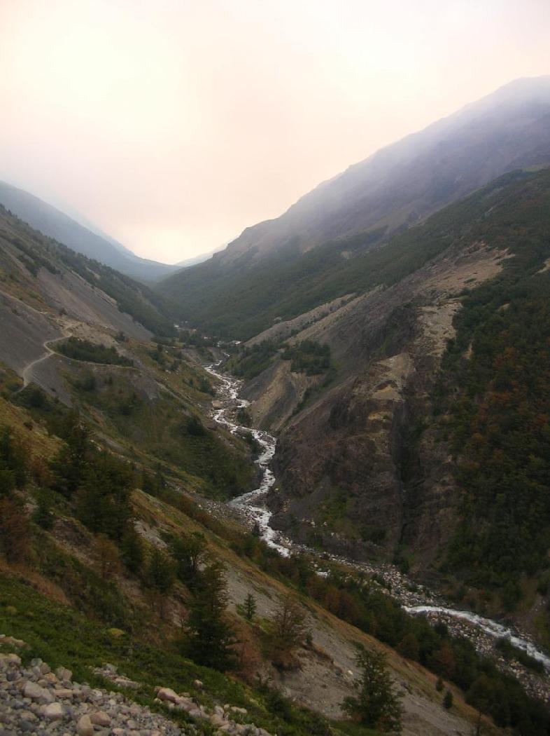
We woke up at 8, still groggy from traveling. We slowly packed our stuff and headed to the new hotel to stash our stuff and check maps to finalize our plan. We planned on an out-and-back around the northeast side of FitzRoy, to the Rio Electrico valley and then up that valley to a refugio which was the launching spot for climbers to attack FitzRoy itself. Beyond that refugio, we knew the trail was too steep and technical to run, so it seemed like a great turnaround point, if a bit ambitious for a one-day out and back. However, an out-and-back was necessary, even if we had to turn around sooner than planned, because we felt we could not yet do an all-day run with heavy packs, which was the only way we could sleep at the refugio. If we tried the heavy packs too soon, we ran the risk of starting Paine later that week already exhausted and/or with blisters that would make it agony to carry the packs. We thought we probably could run the Paine circuit with packs, but only if it was the Paine circuit, with our lives at stake, and not some practice run.Todo: scan map, explain route, give elevation of FitzRoy, etc
It was 10 or so by the time we started down the road to the trailhead. The trail immediately started climbing, and I immediately started feeling sluggish in the legs. Strange, I had certainly had enough rest over the last few days, doing nothing but sitting on buses and airplanes. Then, I also developed a knot in my thigh muscle, forcing us to walk. Not an auspicious start to what was supposed to be an epic day of running, the day for which we had done so much planning and waiting on buses and airplanes.
It was easy to be discouraged, but I knew the trailrunner's wisdom: in
a long event, you always have time to recover. And recover I did.
Here is the view from the top of that first climb (click for full
resolution):
Now we were well above Chalten, but at the bottom of a valley leading
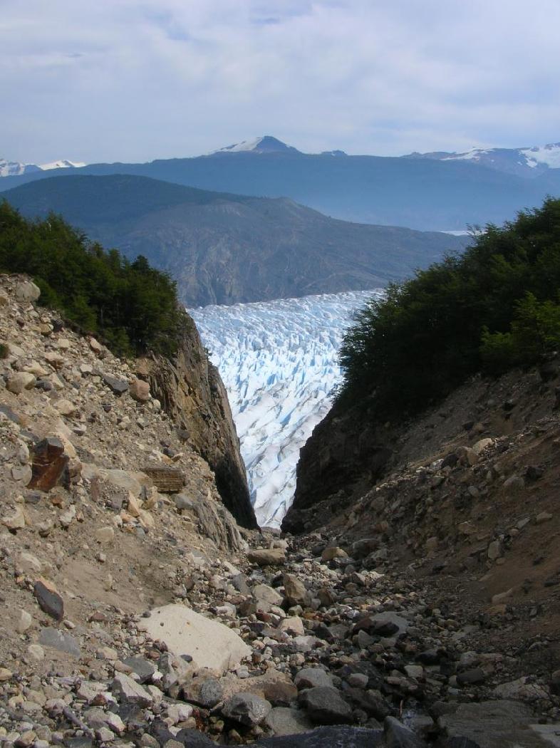
to the approach to Fitzroy. Heading up that valley, we soon got our
first view of glaciers (blue ice easily visible at full
resolution):
The sluggishness fell away without my noticing it, and we were running
well on a reasonably flat trail. At some point we must have crossed
over a saddle point, but I didn't really notice it. After passing
through a campground, we dropped down to the Rio Branco:
This was our first real resupply stop. We squeezed the river water
through our handheld purifier and filled our handheld squeeze bottles
from which we drink on the run. We mixed Gatorade packets in to give
us some calories, and started snacking on Clif Bars and gummy bears.
We then had about a mile of tough rocky riverbed to go down before we
reached the crossing of a tributary. This tributary's valley was like
a playground for big boys. It was filled with large boulders, and we
had to scramble up them for about 800 meters to get to the source of
the tributary, the Glaciar Pedras Blancas, which had been visible far
away as a chunk of blue ice. Here it is up close:
We stopped here for lunch (just Clif Bars? I can't remember), then
went back down the tributary and continued down the main river. The
trail went right down the rock-strewn riverbed, and it was difficult
to run. We eventually crossed a sign and a fence denoting the limits
of the park. We crossed the fence and continued on what must have
technically been private land. However, we were pretty sure it was ok
because the map had made no distinction and encouraged us to continue
down the trail. Eventually we reached a place where we could fork
left. We were supposed to turn left at some point to leave the Rio
Branco valley and start up the Rio Electrico valley to the FitzRoy
approach, but this fork didn't look exactly like the main trail. The
map made it look like the main trail itself turned left. But we were
so sick of the rocky riverbed, which had reduced us to walking, that
we took it, assuming it simply cut the corner a bit.
It wasn't that simple. We did start going in the right direction, but the trail got smaller and smaller. We could hear the Rio Electrico, but there was a hump between us and it. We bushwhacked over the hump and found another trail, presumably the main one, going upvalley. At this point we thought we had successfully cut the corner. However, after a while, the trail got smaller and smaller again, and again we seemed to be not in the main valley. At this point we realized we would not make our destination in time. We had been slower than planned because of the rocky sections of trail, and now we had lost more time going up side valleys. We had to decide on a new plan. Erik wanted to follow this trail up until it ended (obviously not very far), then turn around and go home. I said ok even though I really wanted to start heading home right away. I got more and more cranky as we went up, wondering why we were wasting time and energy when it already looked like it would take a long time and a lot of energy to get home (we had been on the trail for over 4 hours at this point). When he finally agreed to turn around, I realized that my crankiness may have been due to hunger. I ate a Clif Bar on the run down and recovered partially.
We went back down the trail, but couldn't figure out where we had to
get off to reverse our earlier bushwhack. We had surely passed it
when our trail ended in a T with a another trail. Surely this was now
the main one! We had no time to consider this when two hikers came
along, carrying an enormous amount of technical climbing gear. They
had probably climbed to the summit of Fitzroy the previous day and
were now on the way down. I asked one how to get back to Chalten and
he told us to go in the direction I would have thought, and then turn
right at a fallen tree. All this made complete sense, and we were
happy to finally erase our doubts. However, the fallen tree trail
took us down into a rocky riverbed and then it petered out into a mess
of rocks and tiny streams. By all rights, it should have been the Rio
Branco riverbed, but I just didn't recognize it, so I was reluctant to
push ahead without a trail. We went back a bit to check for cairns or
other trail signs, went ahead a bit again, back again, checked our
compass, etc, and finally decided that it
So now we were 100% sure of our location, but we had many
discouragingly rocky miles of riverbed to traverse before the running
became fun again. The rocky riverbed really took a lot of energy out
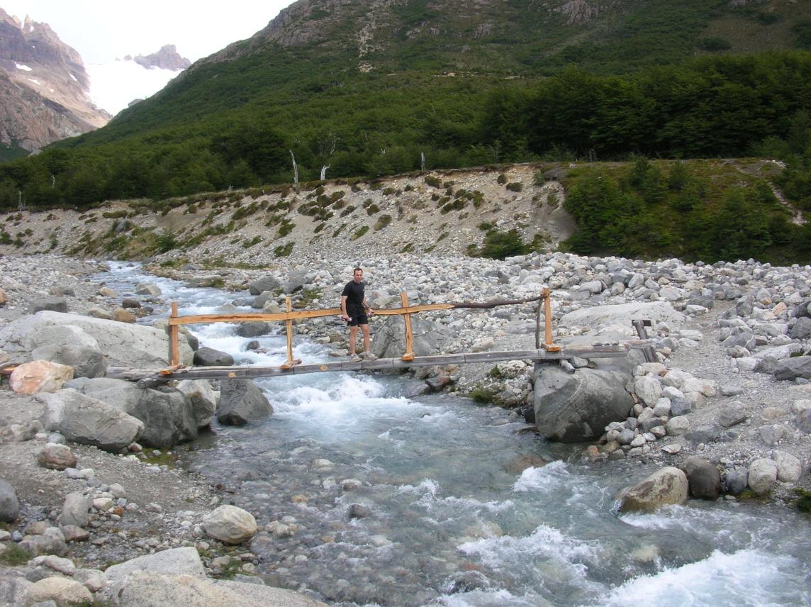
of us, but eventually we recrossed the bridge pictured above and the
trail instantly became nice again. It was a good feeling to be headed
down to Chalten on some runnable terrain. At the small saddle just
before the final descent, I turned around and took this picture of
FitzRoy:
It had been threateningly cloudy all day, at times spitting a bit.
That was fine with me, as I'd rather not have to worry about sunburn
and continually reapplying sunblock. I was very fatigued by the time
we finished the final descent, and I had to ask Erik to walk part of
the 1 km road into town. It seems silly that I could run/walk for 8.5
hours and then not be able to run all of the last, flat, kilometer,
but the motivation just wasn't there. The wind was blowing dust off
the road and into our faces, and this just reinforced the fatigue.
But when we did reach the hotel, I was quite happy and asked someone
to take a picture of both of us (I'm on the right):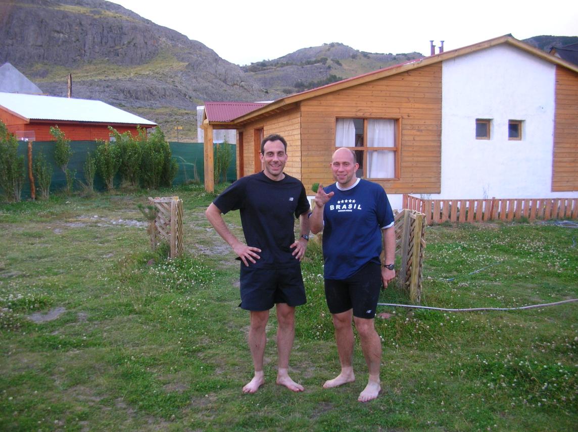
However, that night I was extremely fatigued and could barely drag
myself into the shower or walk two blocks to a restaurant for dinner.
Erik thought I was dehydrated. I had peed only once in the 10-hour
run, rather early on, and I didn't pee again until well after the
restaurant, so I guess he was right. I really felt miserable, and I
had absolutely no idea how I could possibly run again the next day as
we had planned.
Day Four: Epic Day of Trailrunning!
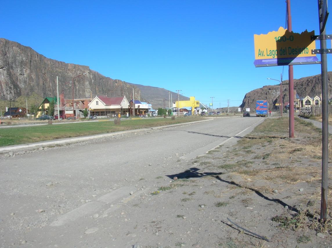
I woke up refreshed. I could not believe how well I had recovered from the previous night. However, neither of us wanted to commit to an epically long day of running, because we were sure fatigue would catch up with us soon, perhaps after only half a day. At the same time, there isn't much to do in Chalten if you return from a run at noon, and we would face the risk of death by boredom. For example, here is the main street:
Laguna Torre is probably the easiest hike from Chalten. After an
initial climb, it's fairly flat, and you can walk there and back to
Chalten in a day even if you are not in great shape. The trail
certainly seemed popular, and we passed many casual hikers who
expressed some surprise at seeing anyone run on the trails. Most of
this trail is pleasantly shaded, but the last half-mile or so goes
over a desolate field of rocks and climbs a bit up to this view of
Cerro Torre looming over Laguna Torre:
It was a cloudless day and I was a bit worried about the sun as we
snacked on the shores of the lake with no shade. On the way back,
Erik said he wasn't feeling too well (now a complete reversal of the
situation last night), but that he would try the big loop anyway in
hopes that he would eventually get better. It was initially a healthy
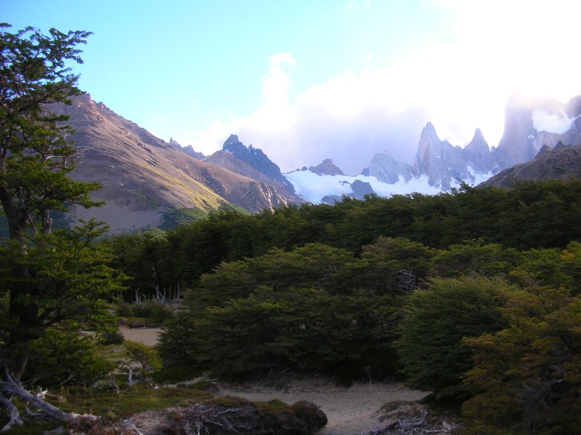
climb, and then we settled into a flat area below FitzRoy:
I needed only a short break to resume climbing, this time at a more
sustainable pace. As we climbed we passed many hikers. The scene
reminded me of some kind of religious pilgrimage. People of all ages
and abilities were shuffling on up: adult daughters with their elderly
mothers, families with small children. The sun beat down on us, but
everyone was determined to get there. Here is what we saw at the
top:
We headed down, not quite running due to the steepness, but still much
faster than any of the walking pilgrims. We even passed people still
heading up, whom we had passed on the way up. I had enormous respect
for these people, who were not young and fit, but were determined to
get to a place that the average tourist would not even dream of.
The rest of the run was uneventful but very satisfying. We cruised
home along the previous day's return route, knowing that we were
having an epic day. If anything, we were less tired than we had been
at the end of the previous day, and well recovered from any low points
we had experienced along the way. The sun was not so hot anymore, and
we had enough energy to take a side trip to a small lake. While
running, we began planning the next day. The original plan called for
a half-day trailrunning and then the evening bus to Calafate, but we
agreed instead to take the 6 am bus. With two epic days in a row,
what was the point of a final half-day which would leave us without
access to a shower before another mind-numbing nighttime bus ride?
Instead, we would take a well-deserved rest on the mentally easier
daytime bus ride.
This time, we ran the 1 km from the trailhead into town. When we
arrived at our hotel, I was feeling good: .
We reviewed the maps and decided on a short out-and-back (about 8 km
(check) each way) due west to Laguna Torre and a nice view of
Cerro Torre. If we really had energy, we would turn left (north) on
the way back and take a trail that reached the Rio Branco again, at
the same crossing we had taken the day before. From there, if we
The final climb to the lake was not a big one, but the pattern is
worth noting. We climbed up an enormous pile of boulders only to see,
when we got to the top, that this pile of boulders is what's keeping a
lake dammed up. The lake is fed by a glacier which comes down from
the mountains and calves into the lake. Presumably the glacier was
larger in the past, and bulldozed this pile of boulders ahead of it.
When the glacier receded, the lake formed. Water was able to escape
only as a relatively small trickle through a low spot in the boulder
pile. This "relatively small trickle" was actually a boisterous river
we had followed for some time. It looked like a small trickle only
when we saw the scale of the lake, the glacier feeding the lake, and
the mountains creating the glacier. This pattern is repeated all over
the Patagonian Andes. 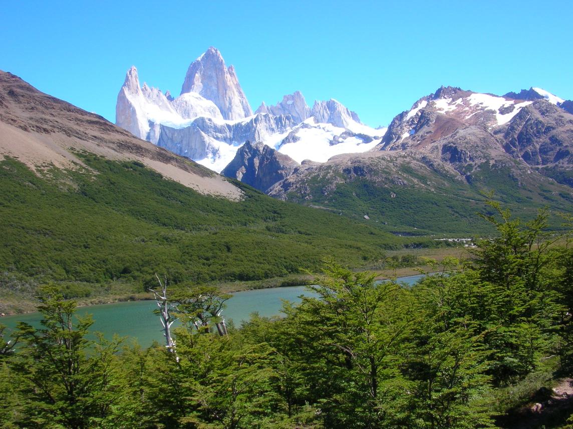
By the time we reached Rio Branco, I guess Erik was feeling better,
because there was no question that we would climb up to Laguna de los
Tres. The climb up was very steep, and within just a few minutes we
were above the treeline and the sun became brutal (for me anyway; I'm
a wimp when it comes to the sun). I soon felt my systems redlining,
and I had to suggest a break when we came to two small trees which
could provide a little bit of shade. We turned our backs to the trees
and found that we were already so high that we could see most of the
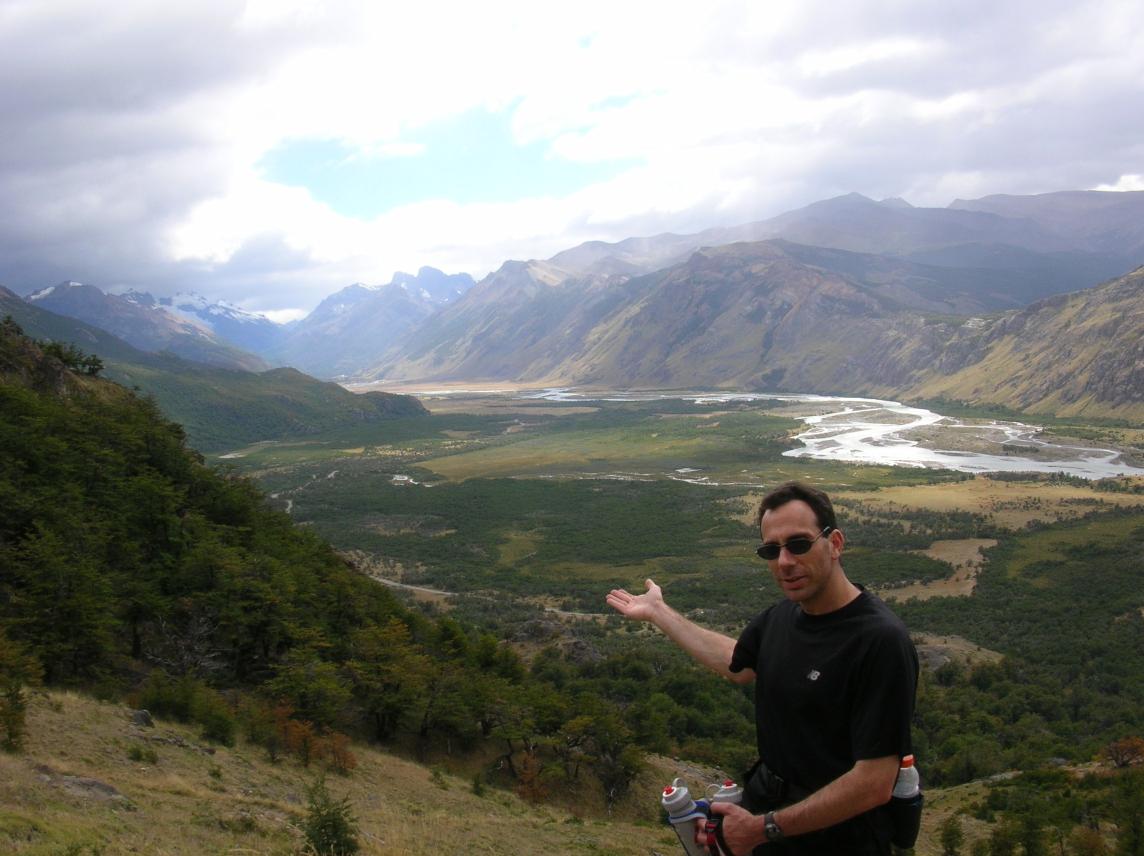
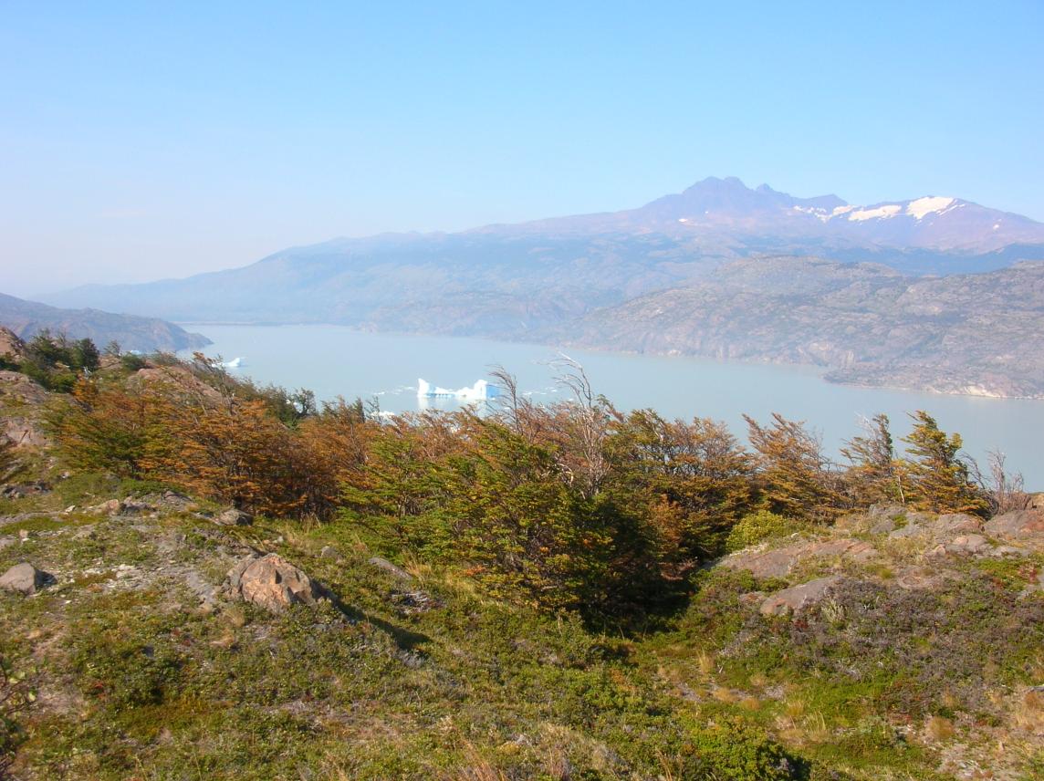
flat area that had taken us more than an hour to cross: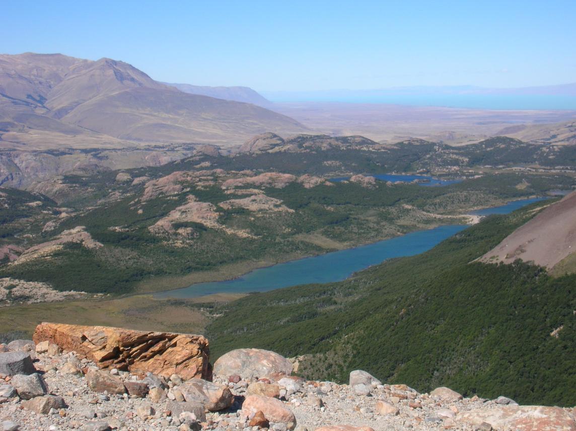
We had come along that chain of long, narrow lakes. The nearest in
the photo, and the largest, is named Mother Lake, then a smaller one
named Daughter, then an even smaller one named Granddaughter. Chalten
is beyond the green area in the photo, perhaps 300 m below it all down
in the dry area beyond. Beyond that, you can see Lago Viedma, an
enormous lake fed entirely by glacier and snow melt from these very
mountains. Viedma drains to the east, to the Atlantic, via the Santa
Cruz River. The turquoise waters of the Santa Cruz flow through a
completely dry, desolate land for the 100 km or so to the Atlantic.
Charles Darwin, in 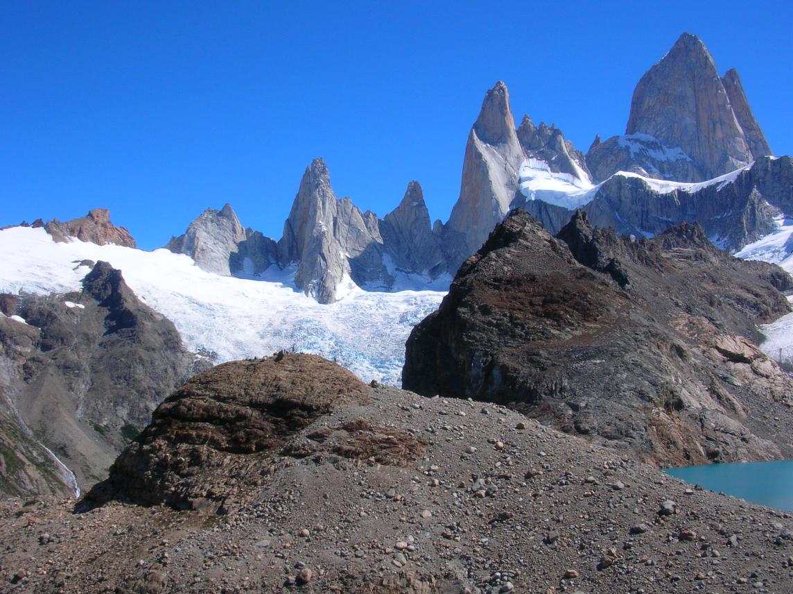
It was definitely time for a break before heading back! A remarkable
thing about Lago de los Tres is that it is a hanging lake. That is,
in addition to the usual boulder pile/lake/glacier pattern noted
above, the whole thing is perched on a cliff at least 1,000 feet high.
The valley below that cliff (to the right in the green photo above)
was once filled with an enormous glacier, which brought it up to the
level of this side valley and prevented the side valley from eroding
down. When the big glacier receded, it left the side valley "hanging"
1000 feet up.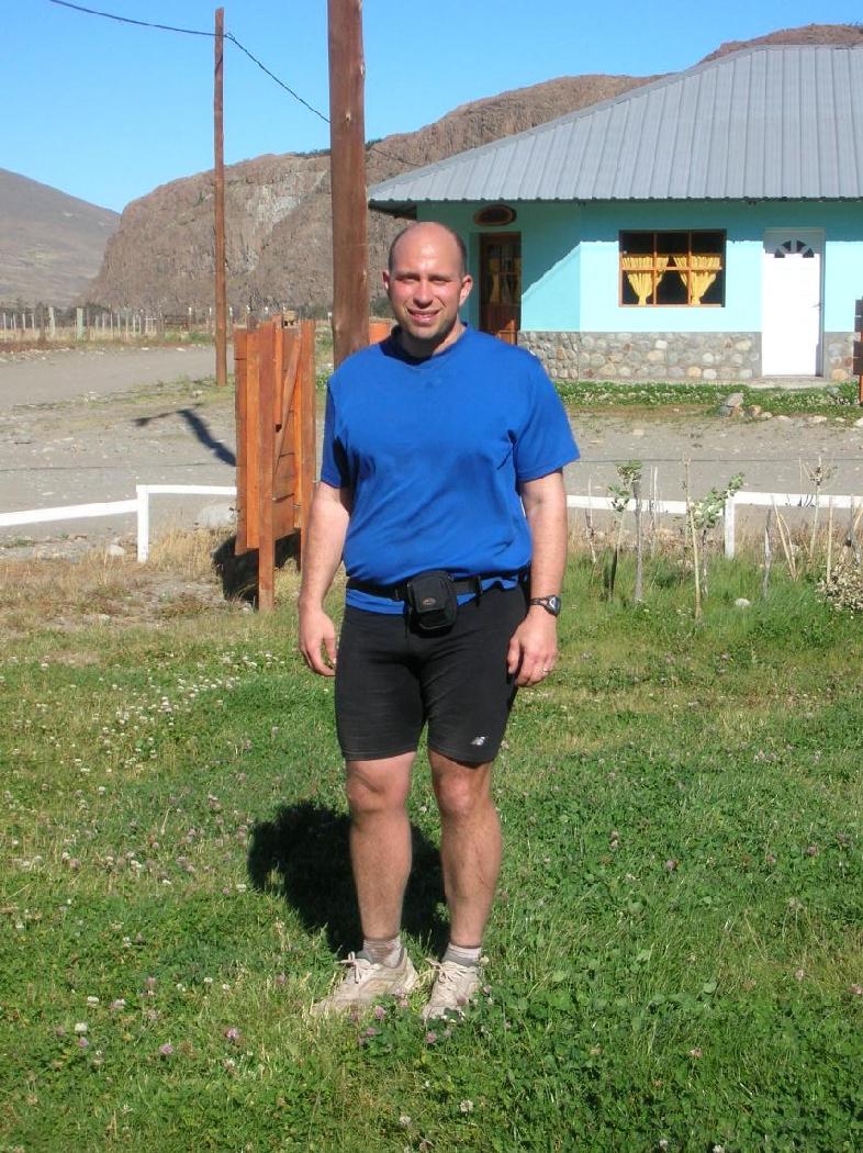
We had seemingly covered more ground than the day before, yet had been
out only 7 1/4 hours. Unlike yesterday, almost none of that was
walking. Runnable terrain really makes a difference! I had none of
the dehydration and fatigue that I had the previous night. I was able
to enjoy the evening meal, and could look forward to the Paine section
of our trip with much greater confidence.
Day Five: Chalten to Calafate
The bus was scheduled for 6 am, and since our tickets were for 6 pm, we wanted to get there extra early to talk to the bus driver. We arrived at the bus stop at 5:45 or so, in almost complete darkness. Gradually,more and more people showed up, making us worried that there would be no space for us. The bus finally showed up at 6:30, and we politely let everyone else get on before asking the bus driver. We got the last two seats. It was 6:45 and light out when we left. It never pays to get too worried about punctuality in South America!This time, the bus was quicker, 4.5 hours, and psychologically much easier. We arrived in Calafate with almost a full day to kill. The return flight to Natales was leaving at 10 am the next day. We took naps in the park (it was too early to check in to our hotel), wrote postcards, called home, tried the calafate-berry ice cream, etc. I was a bit bored, but by the end, I had to admit that Calafate wasn't all that bad.
Day Six: Calafate to Parque Nacional Torres del Paine
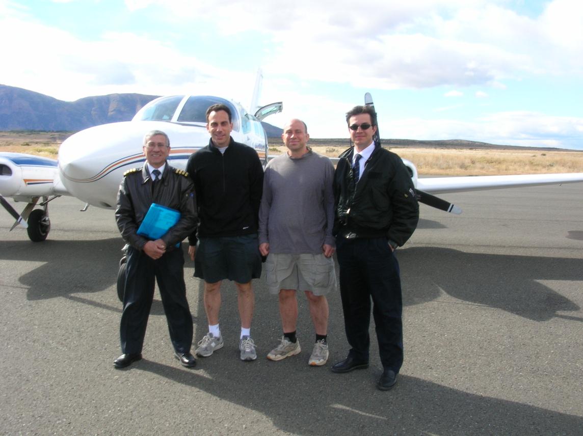
The next day, we went to the airport and met a young German couple who were the only other people on our flight. When they saw the plane, they were shocked at its small size. Unlike us, they had had a travel agent at home research everything and organize their tickets and reservations, so they had no idea how small Aerovias DAP was. But they eventually relaxed and started taking pictures, pointing their camera straight ahead through the windshield. We had the same two pilots we had had before, and after landing we took pictures with them:
We quickly looked for bus companies which ran afternoon buses to
Paine. We stopped in at a travel agency which advertised exactly
that. They were very helpful, but warned us that Paine was
experiencing a brush fire, and we may not be able to do the circuit.
We were crushed, but given the sketchiness of the information, we
still had a reasonable hope that we could do the circuit. We had an
hour or so to kill, and we hit various grocery stores and fruit
markets looking for snack supplies. We ran into the German couple at
one grocery store and helped them buy ice cream.
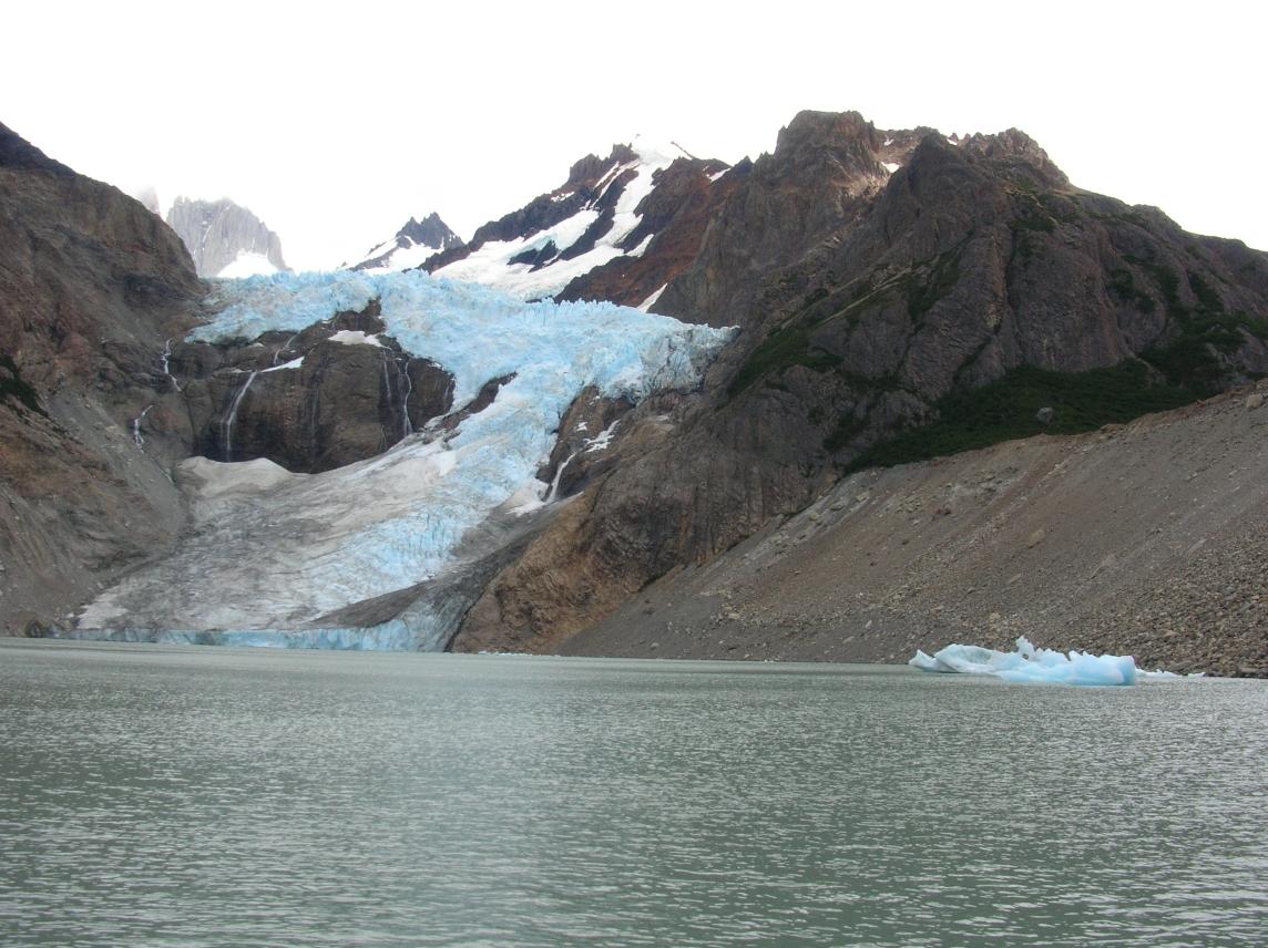
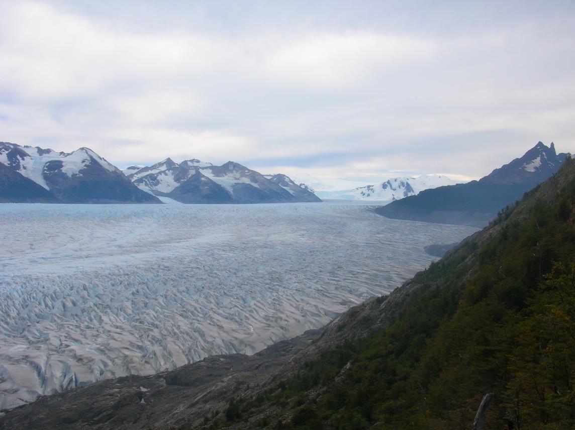
The bus left at 1 or 1:30 pm and we rode it with apprehension about the brushfire. When we arrived at the entrance to the park, we transferred to a minivan for the 7 km along a bruising side road to the Refugio Las Torres, where we had a reservation for the night. The plan had been: Start the circuit counterclockwise early the next morning, with 42 km to complete before lodging at Refugio Dickson on night 2. Then another 40km or so (including a 1,000 m climb over a pass, the day that worried me the most), ending with a stay at Refugio Grey. The next day, a short 12 km to Refugio Pehoe. We could either use that as a "rest" day, or use the morning to go on a glacier trek run out of Refugio Grey before heading to Pehoe. Then another epic day with a long sidetrip up Valle Frances before continuing counterclockwise to Refugio Chileno, very near the Towers viewpoint. The final day, we would get up early to see sunrise hit the Towers, and still have plenty of time to get back to the Refugio, shower, and head the relatively short distance downhill back to Refugio Las Torres, where we would catch transport back to Natales.
We soon found out that no one was being allowed to go in the counterclockwise direction from Las Torres due to heavy smoke. Apparently that area was the center of the brushfire. We would have to innovate. We decided to do the circuit in reverse, thus hitting Refugio Gray on a night for which our reservation was valid, and maybe having some chance of finishing the circuit just after the fire was put out. Meanwhile, we would use the evening for a warmup jaunt up the Rio Ascensio (toward Refugio Chileno and the Towers) as far as we could go without exhausting ourselves for tomorrow, and in the limited time before dinner.
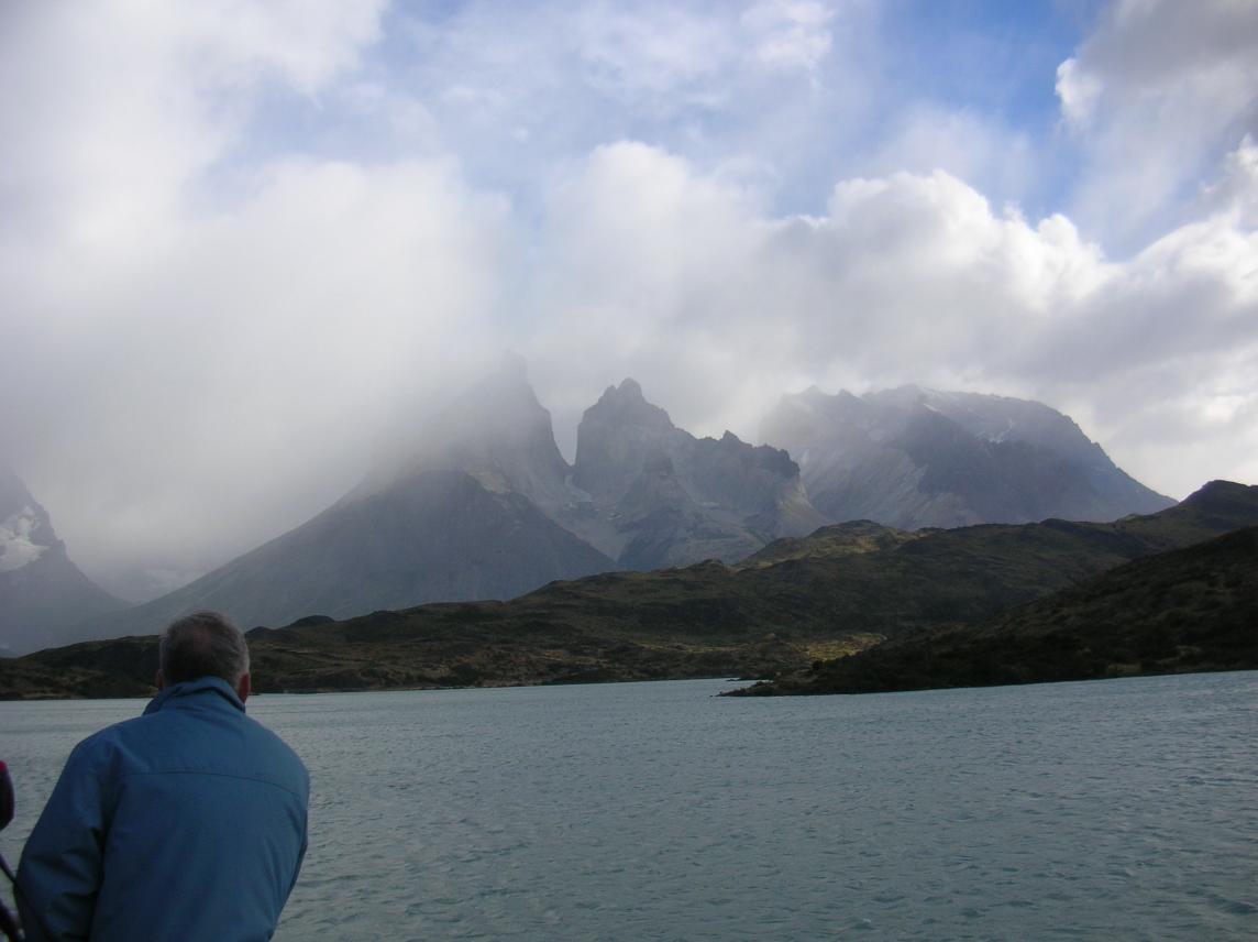
I love the Rio Ascensio. It has a lot of character, and running it is exhilarating. It was certainly my favorite memory from my 1998 trip. Unfortunately, smoke obscured much of the view:
Normally you'd see beautiful snowy mountains back there! Back at our
bunks, we met a Chilean guide whose name I forget, but it was
something British-sounding like Martin. He laughed at us for carrying
purifiers. He said the water everywhere in the park was so pure
already that the purifiers were just dead weight. This was reinforced
at dinner when we sat next to our other roommates, forty-something
Americans named Kathy and Sandy. They were on a grand tour around
Argentina and Chile, with their next stop being sea kayaking in the
fjords. However, they weren't as athletic as you would think: They
were planning on doing only the easier parts of Paine, and were
apprehensive of the sea kayaking because they had never done that
before! I wasn't sure whether to respect their going outside their
normal limits, or advise them to take it easy. Anyway, Kathy and
Sandy said they drank the tap water at all their previous stops, and
had no problems. Nevertheless, we were reluctant to take even a small
chance of getting stomach problems, and stuck with the purifiers for a
few more days.
Refugio Las Torres has expanded since my last trip in 1998 and the dinner crowd is now bigger and the kitchen a bit more like that of a restaurant instead of a home. However, the large tables still help you mingle by forcing you to sit next to strangers (at least if you're in a small group). That's how we started talking to Kathy and Sandy. We also briefly observed a group of fifty-something American women scurrying around. We were to run into them two days later and learn why they were scurrying around so much. It was their first night in Paine, having come all the way from North America, and one of the six slipped in the bathroom and broke her wrist, and was taken to a hospital in Punta Arenas. Another one of the group went with her to keep her company, but returned a few days later to rejoin the four who had stayed in Paine. Even before hearing this story, I had noticed how dangerous the bathroom was. The floor was always wet, made of some dangerously slippery tile, and desperately needed some rubber mats or something. I would almost say that the Refugio Las Torres bathroom was the most dangerous terrain in the park, far exceeding anything on the hiking trail! A good reason to bring flip-flops. The other bathrooms throughout the park were not as slippery,but flip-flops still would have been nice to avoid wet/dirty feet.
At some point that night, I started feeling uncomfortable sleeping on my back. I should have taken this as a sign that my infection was coming back, but I don't remember even thinking about that.
Day Seven: Epic Run from Refugio Las Torres to Refugio Pehoe, with Sidetrip up Valle Frances
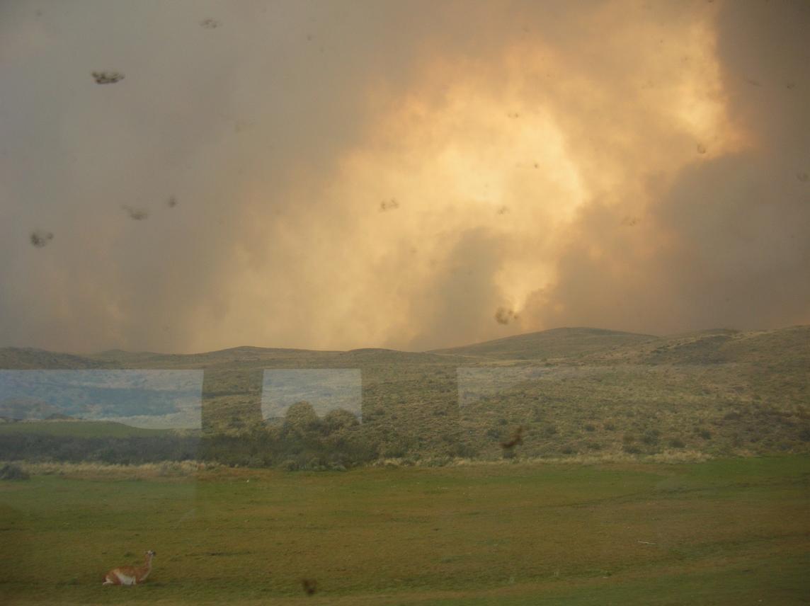
At breakfast, the smoke was incredibly thick. I couldn't believe that they weren't evacuating us immediately. The sun was a pale pink disk feebly sending a few rays through the smoke. The smell of fire was in the air, and so we set out to the west without much regret. I remember thinking that we should hurry, so that we wouldn't have to be evacuated from Las Torres.We left at 9 am exactly, walking the first km or so. This was the first trailrunning day with heavy backpacks, and we wanted to ease into it. (In the FitzRoy region, we just had a fanny pack because we returned to our base each night.) By 9:25 we had crossed the Rio Ascensio, passed a sign saying 4 h to Albergue Los Cuernos, and started to run the less rocky sections of trail despite the heavy packs. We got out of the region of blowing smoke after perhaps an hour total, and found that there wasn't a cloud in the sky. Here is a picture of the transition, somewhere between Las Torres and Albergue Los Cuernos:
Around 10:20 we passed a party going the other way. They asked how
far to Las Torres, and they looked very tired. After warning them
about the smoke and saying goodbye, Erik and I tried to imagine what
adventurous thing they had done to be so tired by 10:20 am. Now that
I think about it, they may have been in the same position as some
people we met later: starting the circuit clockwise before the fire
started, completed 80% of the circuit, then ran into the fire and had
to do everything in reverse. Maybe they were scrambling to catch
their flight.
We began to get nice views of Lago Nordenskjold:
We hit Albergue Los Cuernos at 11:35 am, in half the time the sign had
said. This was good, because we needed to go at twice the speed of
the average hiker to complete the circuit in four days. Regardless of
rocky terrain or heavy packs, if we walked too much, all of our plans
would be disrupted.
We took a quick lunch break, munching on Clif bars while seated right outside the albergue, and a curious thing happened. A party of about six somewhat amateurish-looking hikers came through, headed in the same direction we were. One walked right up to us, and, in perfect resemblance to the type of bumbling Englishman often played by High Grant, asked us, "How do we go that way?" while pointing down the trail. I couldn't believe he was asking such a simple question, so I thought it safest to first make sure I understood his destination. "Are you headed to Valle Frances? No? Campamento Italiano? No? Refugio Pehoe?" He was incapable of stating his destination and, in the end, pointed down the trail again and repeated," I want to go...that way." Luckily, by that time a girl in his group who had been consulting maps or reading signs took charge and headed down the trail. I simply told him to follow her because she knew where she was going. It was all made much funnier by the unintentional Hugh Grant impersonation.
After they left, I wondered how we had not passed them on the way, because they were clearly much slower than us, and we had arrived just before them. I figured it must be that, as they approached the albergue, they had taken the wrong branch at a deceptive fork in the trail, which probably led down to the albergue's garbage dump or sewage pit, and had spent a while stumbling back up to the albergue itself while we swept in on the main trail. There had been at least one point where an inattentive hiker could have gone straight ahead on an undesirable fork while the main trail took a right turn. The trails are very well marked, but you still have to keep your eyes open! So perhaps they had good reason to ask us how to go "that way."
We left the albergue at noon and encountered some rocky terrain from there to the Rio Frances. The trail was easier for the km or so up the Rio Frances to the guarderia where we could dump our heavy packs for the side trip. There was a nice tent they had set up for just that. We arrived there at 1:20 pm and left 20 minutes later after arranging our fanny packs and squeezing the purifier to reload our bottles.
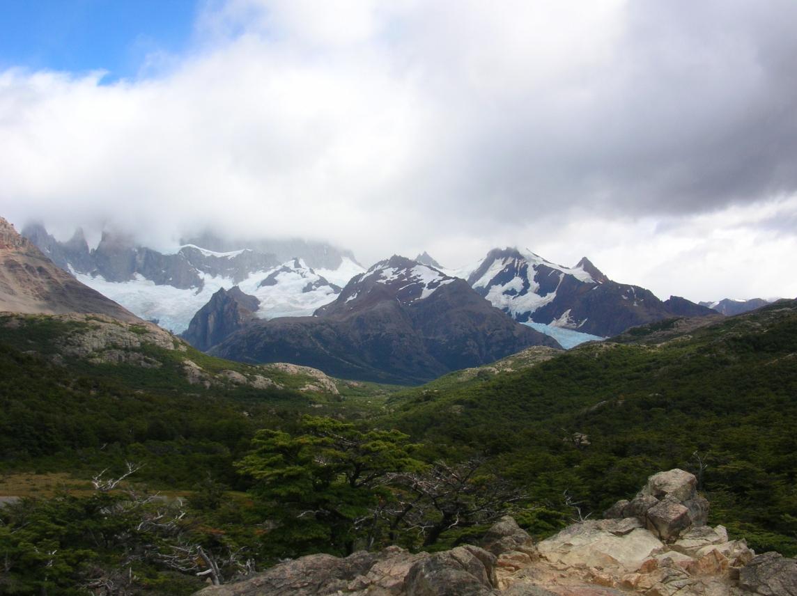
It was a steep 40 minutes of climbing to a lookout over the Glaciar Frances. Unfortunately, smoke was coming down this valley too. The smoke was enough to make my pictures murky, but not enough to smell bad or worry about a health hazard. Here is the view from the lookout:
This lookout is a great place to stop because you have a panoramic
view of the glacier, and every 10 minutes or so, you can see and hear
an avalanche. Yet you are completely safe, being high on the other
side of the valley where there is no snow. We stayed about 40 minutes
and left at 3 pm.
The trail became less steep, but very technical, with lots of roots and rocks. This wasn't an issue on the way up, because we were slow anyway, but it would make the way down slower and more difficult than I would like a descent to be. We topped out at the end of the trail at 4:10 pm, with these views of the back of the Cuernos near the top:
On the way down I started to feel my infection bounce when I ran, even
*without* the backpack. I started to get annoyed with Erik for making
us go all the way to the top when I secretly wanted to get to Refugio
Pehoe as early as possible to make sure we would have a room instead
of being forced into a tent (we had no reservations due to the change
of plans). I became more annoyed with him for going slowly on the way
down. In retrospect, he was rightly being careful for his
questionable ankle on very technical terrain, and I was becoming
irritable and hankering for a bed because I knew the infection was a
looming problem.
We were back at Italiano by 5:20 pm, picked up our heavy packs, and took a 20-minute water/snack stop (it routinely took us 20 m to squeeze 60 oz of water through the purifier). From Italiano to Pehoe, the trail was much less technical, and I wanted to run the whole way to get there as soon as possible. Then Erik twisted his ankle again even on the easy trail, and we had to walk. I was feeling strong enough to run, but it was an illusion. Ten minutes after arriving at Pehoe at 7:15 (just enough time to be refused a room and get shown to a tent), a gust of wind hit me and seemed to instantly suck all the heat out of me. I started shivering and had to ask Erik to bring my pack to the tent. My body obviously couldn't control its temperature. I put on 6 layers of clothes and lay down for a bit. I moved only when I had to go to the bathroom, and then I could feel a phantom pack on my shoulders, dragging me down. The people around the neighboring tent laughed at how stiffly I moved. I was sick, but I didn't know it at the time. I thought it might have been like the dehydration thing at FitzRoy, that I could bounce back overnight.
I ate dinner in a daze, too tired and sick to enjoy the food (not great food, but after an epic day of running, any food should be enjoyable). I ate simply because I knew I had to keep up my strength, which was unusual because I am normally very keen on eating.
Just before going to sleep, as it was getting quite dark, a solo American man arrived in the spot next to us and set up his tent. He said he had done most of the circuit clockwise, then ran into the fire and was now forced to do it all again counterclockwise. So we were now quite sure that the fire would prevent us from completing the circuit. It was very disappointing, but also a relief in a way, because it meant that my infection would not be to blame. Absent the fire, I had still had some hope of recovering from the infection to complete the circuit; after all the next day was a planned easy day, and the day after that I might feel fine. But I knew that was a very optimistic scenario, and the fire took some of that pressure off.
So the practical impact was this. Tomorrow would be an easy day to Refugio Grey where we had reservations. We could get there by lunch. The afternoon could be an out-and-back trail run without packs (ah, heaven, a feeling of freedom). We (or Erik alone, if I felt bad--but I didn't tell him that) would continue in the same direction and see as much of the scenery as we could. The next day would then be perfect for a glacier trek in the morning followed by the short trip back to Refugio Pehoe, where we might be able to get a room-- we had been on a waiting list for weeks, and one of my tasks was to clear that up tomorrow morning before leaving.
Back to the solo American who was reversing all his tracks: This was extra unplanned hiking that didn't fit into his travel plans, so he was forcing himself to do a great distance every day to try to catch up. When we got up the next morning, he and his tent were already gone. We were in awe.
Refugio Pehoe
Camping was almost as expensive as getting a room! I don't have notes on the price, but there were separate charges for the tent, the site, and the sleeping pads, which added up quickly. Plus, room guests were able to get cheaper meals by paying in dollars, which avoided the value-added tax. With a miserable night in a cold tent ahead of me, I didn't even have the comfort of knowing that I was saving money!
Refugio Pehoe is the largest and most modern refugio in the park, and
eating dinner there was just like eating at a cafeteria
anywhere. Except for the view of course:
The above picture is not quite from the Refugio itself, but from a
nearby hill looking back to the Cuernos at sunset. But the view from
the cafeteria was almost as good.
I very much enjoyed staying inside the refugio two nights later. They had a nice lounge for room guests only, with big comfy chairs and a fireplace, games to play and magazines to read, phones which accepted Chilean calling cards (you did buy these before traveling to any remote areas, didn't you?), and internet access that didn't work the night we were there. The bathroom was also by far the cleanest and nicest in the park. (Note to other refugios: would it kill you to provide a hook or shelf near the shower stalls so that I have a dry place to put my towel and clean clothes to wear? The designers of the Pehoe bathroom actually thought about how people would use it, and gave us these amenities.) Meanwhile, tonight, the bathroom for campers was in a separate, unheated building. It was cold but not intolerably dirty, and I forced myself to take a shower despite the cold air, in hopes that the water would warm me up.
Other observations regarding Refugio Pehoe: There is a store where you can buy supplies. And the reservations system clearly doesn't work; see a few paragraphs below.
Day Eight: "Easy" Day to Refugio Grey
I didn't sleep well. I could not sleep on my back because the infected area was sensitive, and every time I rolled over, I could feel that the hard spot on my back was bigger than before. I was warm enough with six layers of clothes plus my sleeping bag, but my nose was very cold. The ground was hard. When I woke up, I could feel that the infected area on my lower back was literally ten times larger than it had been before. Now it was something like the size of a dollar bill, all hard like it wasn't even part of my body. I had to ask Erik to try to drain it. Unfortunately, he didn't find anything to drain. It was all hard without a central area to drain.When I crawled out of the tent, I found condensation and frost on the outside. So much for leaving our towels outside to dry! My notes say "Despite the size of the infection and my fatigue last night, I don't feel bad overall." Hmmm, that didn't last long, because I remember most of the day as hell! Anyway, I checked on our waiting list status for the following night. This was the only place on our original plan where we hadn't been able to get reservations. We had consistently been told we were on a waiting list. I went to the desk and was told that we were still on the waiting list. However, they had space tomorrow night and would give me a room if I paid now. Does that make any sense? It's typical of trying to organize a trip here. You just have to keep checking and asking. Annoyingly, the receipt they handed me didn't have the date of my stay on it, so I had some doubt about its validity right up to the moment the following night when they escorted us to our room. I made a point of keeping the receipt handy, because I had a feeling there would be a problem when we showed up asking for our room. Sure enough, they hadn't marked us down as paid, but I had the receipt proving it.
We agreed that it would be an "easy" day, with just 11 km to Refugio Grey, where we had reservations for tonight. If we felt good when we arrive there, we'd take an additional out-and-back from there to scout out what's ahead. We started by walking somewhat slowly in hopes of sparing my back so I can run after we drop our packs at R. Grey. But it is the longest 11 km of my life! Erik also thought that the distance was understated, and he is more credible because he didn't have a raging infection. (But he must have been tired--he claims not to have noticed that we were going slowly!).
The trail climbs up from Refugio Pehoe, skirts a smallish hanging
lake, and then follows the shoreline of Lago Grey, but high above it.
About midway, there is a significant bend. Before that point, the
best views of the Lago Grey are looking back:
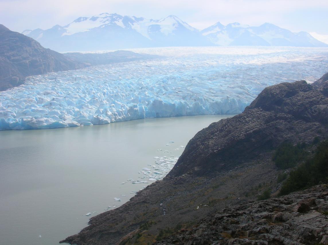
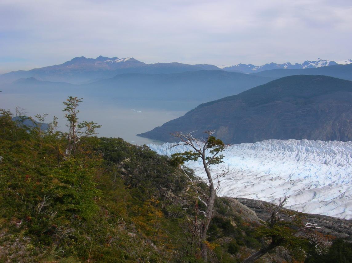
And after the bend, you suddenly get a view of what's ahead:
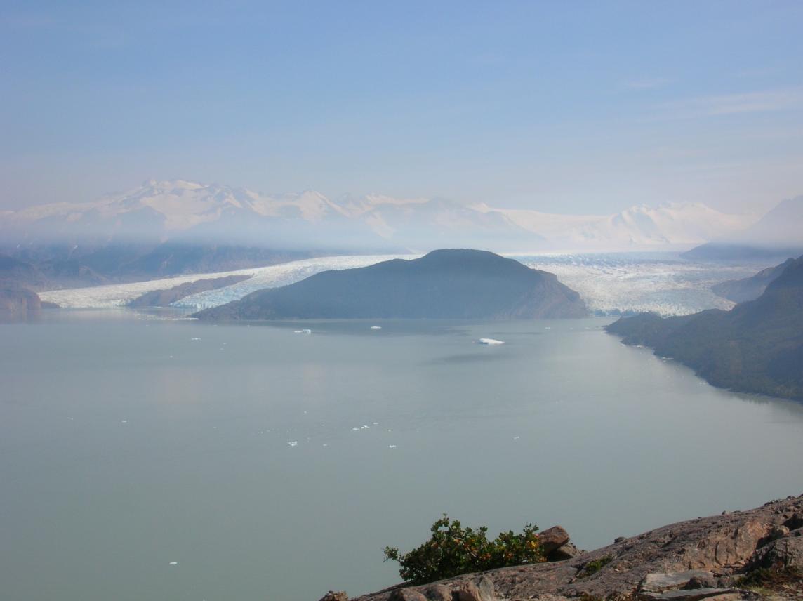
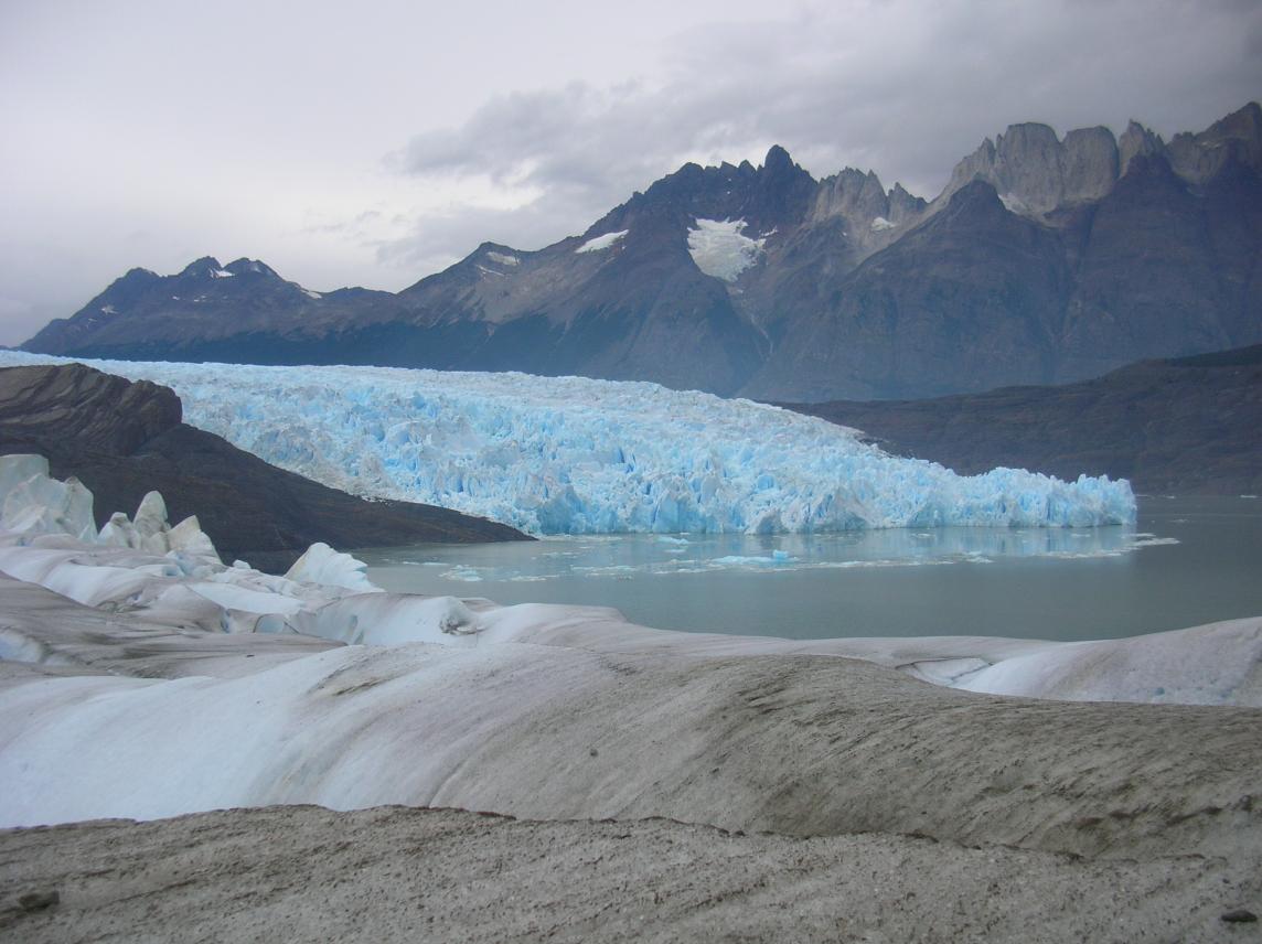
That's Glaciar Grey ahead of us, an extension of the southern
Patagonian ice sheet which stretches north for 200 km from here.
Refugio Grey is on the shore, just shy of the glacier. Tomorrow
morning, we have an opportunity to take a trek on the glacier. Now
that we can see our destination, we think it must not take too long to
get there. But the trail stretches on seemingly forever. In the end
it took us 3:10 on the move, plus a 40m rest/picture break in the
middle. The entire second half, we were convinced we were close to
the end, so I kept pushing ahead rather than take it easy, even though
I was not having fun.
Finally we reached Refugio Grey, and as soon as we stopped, I again found that I couldn't control my temperature. I was terribly cold despite the mild temperature and the sunshine, and I put on 6 layers. I told Erik that that "11 km" was as hard as the Death March (a story I had told him about a past adventure). The Refugio was still serving lunch, and we sat down to eat in the vain hope that hot food would strengthen me. I ate in a daze again, and Erik later told me that I looked completely out of it during this meal (as I indeed felt).
After lunch, I felt slightly less bad, but, still unable to control my temperature, I simply crawled into bed with my 6 layers of clothes on, plus sleeping bag. We briefly meet our roommates, who were the four fifty-something American women we had seen scurrying around the Refugio Las Torres two nights before. We had run/walked to Refugio Grey and they had taken a boat (Refugios Pehoe and Grey are both right on lakes, with boat access). Thank goodness they went out for an afternoon walk and left me to sleep in peace, without asking too many questions. At the same time, Erik left for his afternoon run.
I slept much of the afternoon, which is amazing considering the noise in the building. Refugio Grey is a very small, cozy building. The dormitory rooms are upstairs, and it's easy to hear people coming up the stairs. Plus, the peaked roof is open to all the rooms, so that sound carries easily from one room to another. In my sleep, I heard young people chattering in the other room, but they could not completely disrupt the sleep of the dead which gripped me. However, I still cannot get out of my head a phrase they repeated often, said with much gusto in European-accented English: "From Russia!" Apparently they were making fun of someone they had met, but they succeeded only in making themselves sound ridiculous. I was so happy that those people were not in my room that I could drift back to sleep contentedly.
When I woke up two hours later, I had that post-sick feeling like I died and was reborn and have to start building up my energy reserves from scratch again (plus, in this case, with really, really tired legs). I stayed in bed for a bit, ate a Clif bar, and wondered how many layers of clothes to put on for a walk. Based on the weather, a normal person would have worn a light shirt with a light jacket, plus light pants or shorts. I put three layers on top, plus shorts with heavy sweat pants over that, just in case I lost my temperature control again. I could always take them off if I got too hot. I started walking very slowly down the trail. I hoped to get to a vista point about half a mile away where I could view Glaciar Grey. (Take another look at the glacier photo. See that point of land just shy of the glacier? That's it.) But my main goal was just to get some fresh air and assess my condition. Could I possibly do more hiking tomorrow? Or would I have to be medevacked out?
I obviously didn't judge my body correctly, because I began to
overheat after one or two hundred meters. I took off a few layers,
but I was too tired to go back to the refugio to drop them off! I
opted to carry them, despite not having a pack to put them in. After
a while I seemed to stabilize. I made it to the lookout without too much
stress, and stayed there comfortably exhausted for an hour, enjoying
this view:
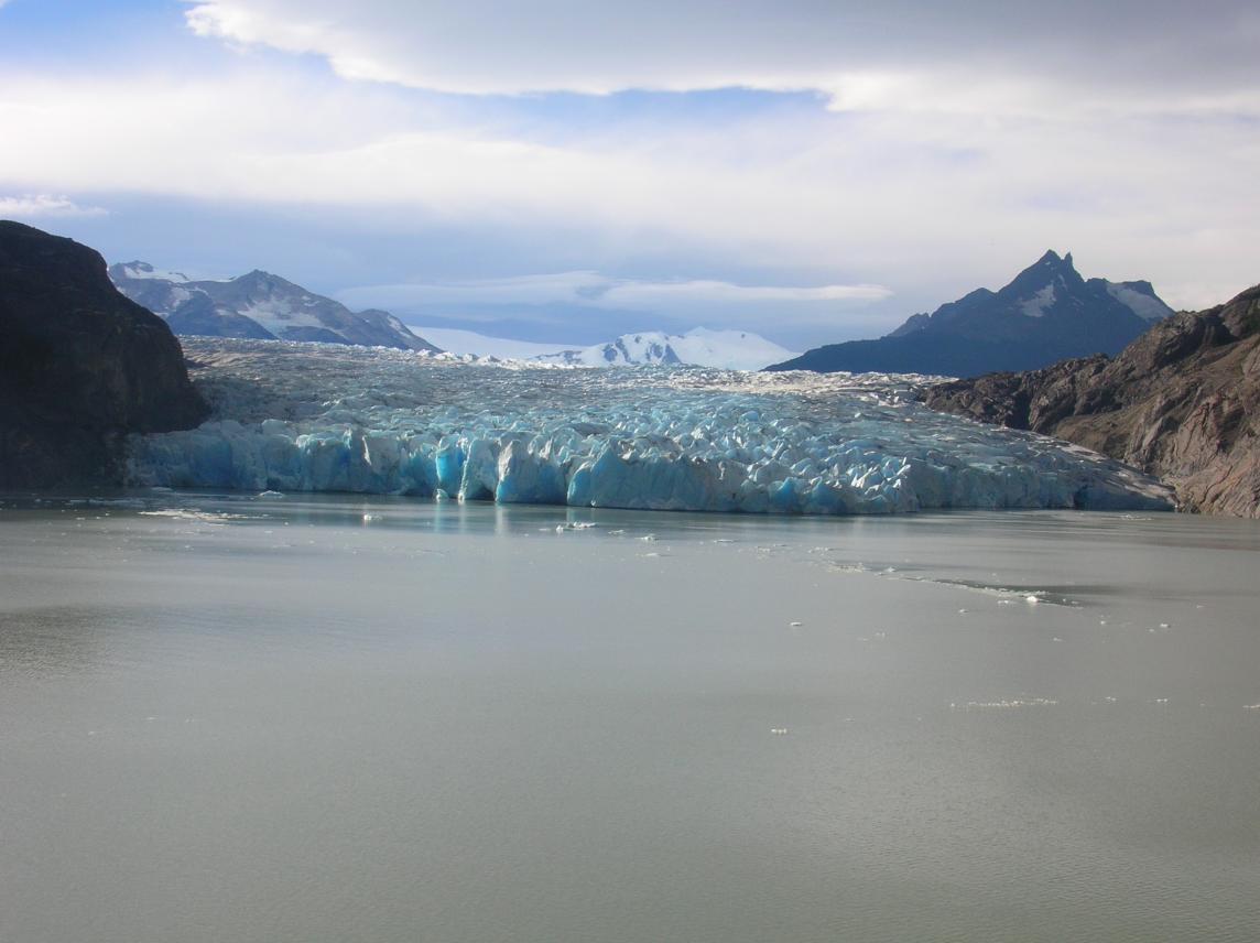
During that hour, I heard many loud cracks coming from the glacier and
expected to see some icebergs calve, but none did. Also, Erik
arrived, surprised to see me, and related his story. He had done a
4-hour run, hoping to to get to Campamento Paso. Afraid of taking too
long and missing dinner, he had turned around just shy of there, but
then discovered that the return trip was much faster, and here he was,
well before dinner. Here are the pictures he took heading up
alongside the glacier:
And on the way back, with the lake coming into view again:
He said it was pretty rough terrain, very steep at points,
and at one point even with a ladder. It seemed very doubtful that we
could have run it with heavy packs.
We leave the glacier vista at 7, which is when they told us to arrive at dinner, but they can't be upset if we get there at 7:15 or 7:20, can they? Yes, they can, because there are two seatings and the first seating must finish within the one-hour time period. No problem, I eat quickly! Dinner is the same as lunch: beef stew with rice (ok, lunch was mashed potatoes instead of rice). We start to drink the water without purifying it---the turning point was when I drank the juice they gave us for lunch and realized it was reconstituted with lake water.
After dinner, we talk with the "golden girls" (Erik's nickname for the four American ladies of a certain age sharing the three-bunkbed room with us). Their leader is named Maxine. We had seen them briefly in Refugio Las Torres, and now they tell us the whole story of their friend with the broken wrist. She had to be driven to Punta Arenas for surgery, and the friend who accompanied her there was due back tomorrow. They said the woman who slipped was a good athlete, confirming my suspicion that the Refugio Las Torres bathroom is the most dangerous terrain in the park. They said how great it was that they had arranged their trip through a Chilean agency named Comapa and how their agent came from Punta Arenas to help them when the woman broke her wrist. They also say how they have been drinking the water throughout, with no ill effects.
They tell us some other interesting travel stories. They had just been talking to an English couple (whom we had seen downstairs at dinner) who have been traveling for 11 months continuously. That couple's worst story was about being abused by the Peru/Bolivia border police, and their best story was about finding a lost camera and returning it to the owner. Months later they met some people who told them about a friend who had miraculously had a camera returned to him; asking for details, they confirmed that it was the same person they had helped! Strange, I had noticed at dinner how the English woman knew NO Spanish, and now I learn that she has been traveling in Latin America for many months...I guess everyone has their own style of travel.
Anyway, I had been waiting for a private moment where I could ask Erik to drain my infection again. It was now clear that the golden girls were settling in, and I felt like we had broken the ice enough that we could do it in their presence. So I started explaining what we were about to do, just so we didn't offend them, and instead of being disgusted, they really tried to help. Maxine gave me some antibiotic pills she had along "just in case" and I gratefully accepted. Erik still didn't find anything to drain, so those antibiotics were the only good result of the whole effort! I'm so tired, I skip taking a shower, reasoning that I can do it in the morning.
Refugio Grey is really dark at night. As in, the generator is off and the light switches don't work. The first time I went to the bathroom (downstairs), I wasn't expecting this! It took a loooong time to negotiate my way to the bathroom and back. The second time, I grabbed my headlamp before leaving the room.
In my sleep, I sweat like a pig. Not sure if this is fever or just how hot my sleeping bag is. Other people must be hot, because they have opened the window wide. But the wind is coming right in onto my face, making me cold...I can't find the right balance.
Refugio Grey
Refugio Grey is charming, the picture of a Refugio. The building is small, wooden, and cozy. Downstairs has a cozy kitchen and dining room, plus bathrooms which are far too small and a bit out of date (e.g. no running hot water in the sinks; you must wash hands with cold water). Upstairs there are about three dormitory rooms open to a peaked roof. The electricity goes off at night and there is NO light to help you get to the bathroom downstairs. I highly recommend a flashlight or headlamp!There is also a store where you can buy supplies (in another tiny building), a campground with its own bathrooms/showers, another building housing the glacier-trekking guide company, and a boat dock, with daily service.
Day Nine: Glacier Trek and Easy Run Back to Refugio Pehoe
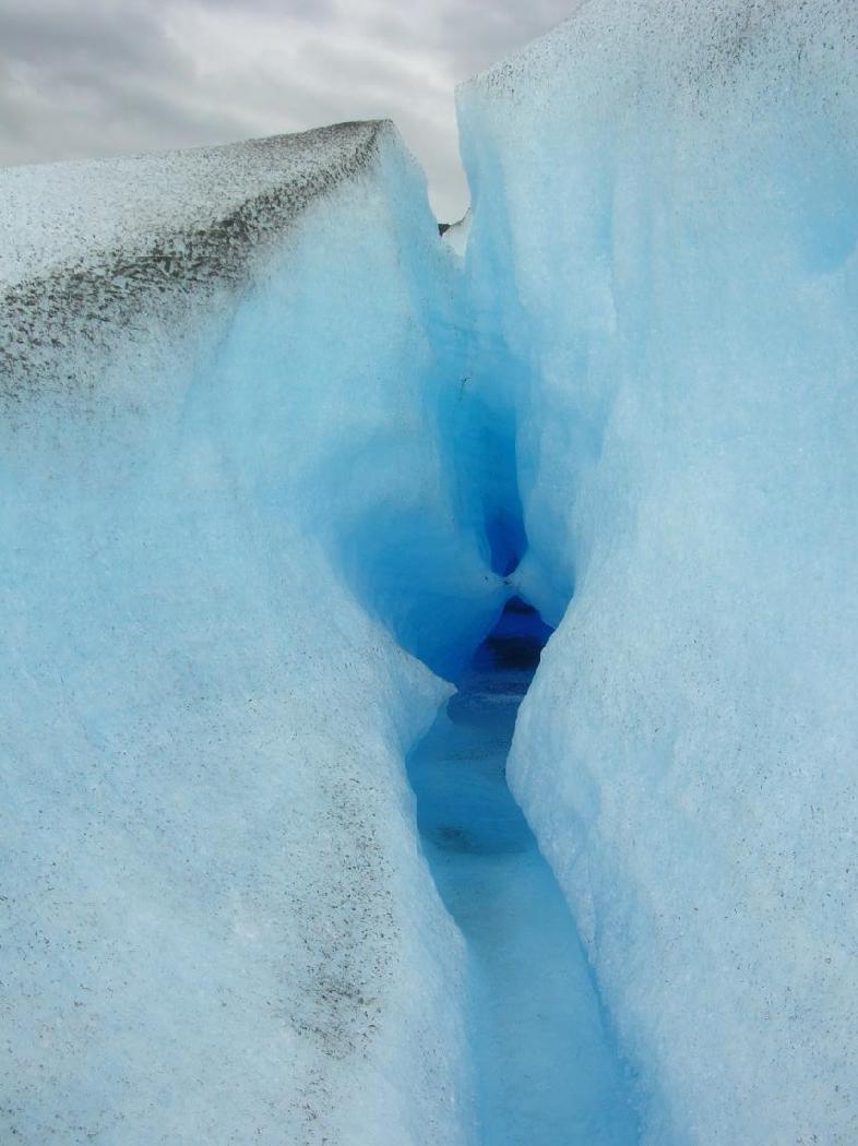
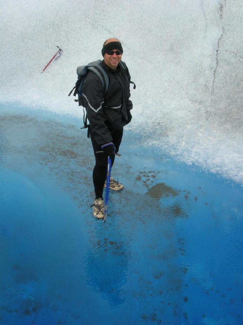
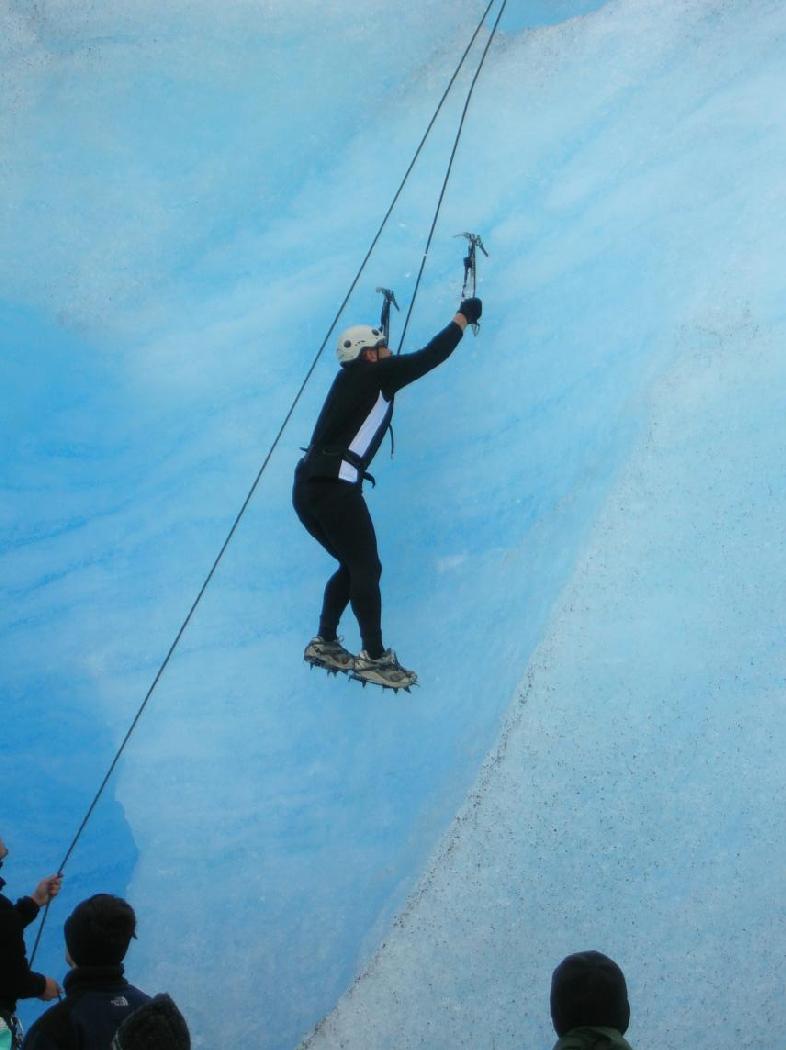
When I woke up the next morning, I felt that I could handle the glacier trek. So this is the one day that will go as planned before the fire; glacier trek, then short "11km" hike to R. Pehoe, where we already have a paid room.The glacier trek was pretty easy, even with some lingering fatigue from my illness. We took a small motorboat across Lago Grey, walked around to see the most interesting features (example: the glacier has its own river system, mostly below the surface), and did a small ice climb at the end. Our group of about 10 people included a very spry sexagenarian couple. In the ice climb, the guy (Jack) scampered up very fast (admittedly up the easy route, but still). I was first up the more difficult of the two routes, but my crampon came off at the top of the climb and I was lowered in a very undignified position. Erik's crampon came off too, but he was able to one-foot it down gracefully until the end, when he lost control as well. Lesson: wear stiff boots which will not curve out of the crampons.
The glacier trek cost US$100 for a couple of hours. There were two guides, one American and one Chilean, who spoke just enough English to guide us. It's pretty expensive, but I'd still recommend it, because how often do you get to trek and climb on a glacier?
We got back in time for a real lunch served at R. Grey. Lunch
again is beef stew with mashed potatoes!! We set out for
R. Pehoe at 2:35 pm in an intermittent rain, ranging from very light
to worrisome, enough to make us put our pack covers on for the first
time. It's also fairly windy (the first time on the trip I really
feel like I'm in windy Patagonia), but the wind is at our backs. Just
before we go around a corner, we get a last view of Glacier Grey and
the weather looks pretty nasty there---I'm glad we're not in the
afternoon glacier trek! It gets clearer as we go south, and the
second half is actually sunny in many places. Obviously we (or at
least I) felt much better than on the previous day, as we actually ran
some of the later flat and downhill stretches. I even tried to outrun
Erik for about five minutes as a test of my strength. We finished in
2h41m, including the two small breaks we took.
I must have been really sick yesterday, judging from how much better I feel today. I must have been really out of it, because I can't remember various things that Erik says happened that day---details about things we passed and things he pointed out to me as we passed them. One gratifying thing though--40 minutes out, we encountered 2 men going the other way, who ask us how much further. When we say 40 minutes, they look like they can't believe that it's that far. So maybe everyone feels that it's longer than 11 km---maybe it IS longer than 11 km. So maybe we weren't doing so bad yesterday.
We arrived at R. Pehoe at 5:06 and I felt like I could run more, but decided it was unwise to try. We settled for a short walk up a steep hill which gives an expansive view of Lago Pehoe.
Inside the refugio, we met an older American couple clearing out of our room. They were about to catch the 6pm boat, leave the park, and head to the FitzRoy area. We gave them advice to take Aerovias DAP to Calafate. I felt especially good about being able to give them the correct phone number; not speaking a great deal of Spanish, they may not have been able to figure it out had they called the number in the book. They told us that Albergue Chileno was closed, dashing our hopes of seeing the towers on the way back. Right after they left, we met our roommates for the night, a Swiss girl and her silent boyfriend who say that A. Chileno is open and that she heard that within the last hour, so it's presumably better than the previous information. We decide not to believe any information until we leave in the morning, and even then we will go straight to the park ranger for our info. Still, we hatch a good alternative plan in case it is closed---take the boat and bus to the part of the park furthest from the fire, try to get a room at the Posada there, and then do some day runs on lesser-known trails in that area of the park. Normally, we would not have considered the part of the park furthest from the mountains and glaciers, but we were open to anything that would let us see more than smoke.
The Swiss girl is in Chile for a year, volunteering in a Santiago hospital, and this is her one week of vacation for the year. Tonight is her second night in the park, and it looks like her entire vacation could be ruined by the fire. So I don't feel too sorry for myself.
Dinner at R. Pehoe again is beef stew with mashed potatoes!!! I ate everything, as I did at all the other meals, but for the first time I feel like I ate too much, like I hadn't worked hard enough to eat all that. (We did meet someone who said that the portion sizes were huge at all the refugios. We has always been too hungry to notice!) Dinner costs US$12 for Refugio guests, more for campers. I take my 2nd Cipro, thanks to Maxine.
For seemingly the first time in Paine, I showered (and shaved! I discovered Erik has been lugging around a ridiculously heavy can of shaving cream) and washed my clothes before dinner, and ate dinner as soon as it opened, so now I have both time and energy before it gets dark and bedtime approaches. I try to use the Internet (Pehoe is the only refugio with internet), but it's broken, so I snuggled in a comfy chair in the lounge and started to write about the last few days. Erik also writes in his travel journal, which he does almost every day. When we're both tired of writing, we go to our room and discover the Swiss couple sound asleep. That's also a first---I've always been the first one in the room to sleep, presumably due to fatigue. But they're champion sleepers--they also sleep through us getting up in the morning.
More Thoughts on Refugio Pehoe
R. Pehoe is a big business, not a charming little refugio. In fact, it calls itself a "mountain lodge", not a refugio. Bathrooms are clean, spacious, with soap and paper towel dispensers (though the towels are out), places to put your clean clothes during the shower, etc. And the rooms have window seats with storage cubbies underneath! That one detail makes things so much easier. Yet the price is the same as all the other refugios--must be a park regulation. R. Grey had its charms; Las Torres was dirty without any real charms; and R. Cuernos was charming judging by what I saw of its kitchen area and it's new, so maybe the bathrooms are nice too. In contrast, R. Pehoe has a massive cafeteria with staff in uniforms, and a bar upstairs offering 2 for 1 pisco sours ("pay one, get one free"--not standard English but actually makes more sense than standard English!). Too bad having clean bathrooms seems to require a corporate mentality.As mentioned above, Pehoe has a nice lounge for guests, with magazines and comfy chairs. It's a great place to write a postcard home or take notes in your travel journal (which for me was the back of miscellaneous receipts, because I hadn't thought in advance to take a travel journal). However, one sad aspect of it is the large photographs of natives on the walls. So sad that they are all gone, replaced by this business, and I am supporting it...
Some final random thoughts I jotted down: Patagonia is windy. The flags flying above R. Pehoe are all tattered by the wind. It's my eighth day without caffeine, and I have had no withdrawal effects whatsoever. (But when I get back home, I soon go back to drinking enough Diet Coke to float a battleship. Erik manages to kick the habit for good.)
Skipping rocks on Lago Pehoe.
Day Ten: Evacuation!
The next morning, taking the boat to the southwest corner of the park, as far as possible from the fire, seemed like a good idea. Smoke was pouring through the Valle Frances, reaching us all the way through the mountains from the dry, eastern part of the park where the fire was raging. The smoke was mixed with clouds and perhaps light rain, so an optimist could imagine that maybe it wasn't that bad. The Swiss boyfriend was in a bad mood, but insisted to his girlfriend that they must try seeing Valle Frances. We felt sorry for her, because she seemed like a cheerful person.
We got on the boat happy to be heading away from this scene:
But about halfway through the boat journey, it was announced that the
park was bein evacuated. When we landed, we would be picked up by
buses and driven out of the park. This should have been very
disappointing, but actually it wasn't so bad. It ended many days of
uncertainty. And it gave me hope of fighting off the infection,
because I would be forced to stop running with a heavy pack. At the
same time, I didn't want to spend two extra days waiting in Punta
Arenas for my flight. I had mixed feelings.
The rest of the day was frustrating. We were told to hurry up and board the bus, which drove from the boat landing to park headquarters, as is its normal route. There we waited; normally the bus would wait there an hour or so for lunch break, but we were told that we would go as soon as we got word that it was safe. Apparently the fire was threatening the road out of the park. We kept asking for information, but no one knew anything for sure. It was suggested that if the fire didn't let up near the road before nightfall, we would have to sleep on the bus right there.
It was frustrating, but it brought us trekkers closer together, as the ones who spoke better Spanish relayed information to the others, and we all speculated on what might happen. Sitting just in front of us were a young American couple, and we started a conversation. They were from upstate New York, and were spending something like a year trekking all over. They had done places I had only dreamed about because they were too remote to reach in a short vacation, such as Circuito de los Dientes in Tierra del Fuego. They were young people with a lot of time, but no money. They camped everywhere and economized everywhere, and this allowed them to see the world. I respected that. I also remember their good humor and twangy speech. We talked about whether water purifiers were as necessary as the books said, or as unnecessary as the people said. The man's summary of the situation was that he had seen "beaver fever" in rural New York and it was not a good thing. We ended up going to lunch with the couple, at a small restaurant about 400 meters away. We made the bus driver swear to get us if they got the order to move; because of trees, we would not be able to see the bus from the restaurant. And all our things were on the bus!
We had a good conversation, but the restaurant was a bit slow, and we were getting nervous about being away from the bus so long. Sure enough, we got the word just before our food was ready. But somehow the restaurant staff didn't believe that we had to go. We ended up in the kitchen, pleading with them to put the food in a bag. We ran to the bus with our food, and it all worked out. We had some nice hot food as the bus started rolling. Strangely enough, the bus was leaving at exactly the scheduled time, and didn't do anything other than drive back to the boat landing to wait for word that the road was clear. Why didn't they just tell us they were going to do that?
We waited for about two more hours at the boat landing, where many buses were lined up. I saw a monstrous vehicle with a monstrous trailer roll by, painted with the slogan "Rotel, das Rollende Hotel." Apparently people spent day and night on this thing while they traveled around. But why were they allowed out of the park while the rest of us were waiting? Because the vehicle was built like a tank?
While waiting, we had a brief conversation with the two girls behind us, who were from Belgium. We had run past them on the trail yesterday (though I didn't remember, Erik did), and they now asked us if we were "sporters." Erik said, yes, I guess we are. We were very impressed by their language skills. Their English was very good ("sporters" was their only mistake, and it looks like it should be an English word); they were speaking French to some other tourists; I heard them ask the drivers and officials for information in Spanish that was much better than mine; and to top it all off, when they spoke to each other, it was in a fourth language that I assume was Flemish.
After about two hours, we got the signal to roll. That was exciting.
We flew down the gravel road much faster than normal, and it became
clear the driver was racing the fire:
After about 15 minutes, we were clear of the fire, and we made it to
Puerto Natales peacefully. We got a bus to Punta Arenas the same
night and arrived rather late (10pm) and tried to find a place to
stay. We went to Hospedaje Blue House or something like that, and it
was way too crowded with people having a good time, watching sports on
TV and talking animatedly. If you like that atmosphere, Blue House is
for you. But we wanted something quieter, so the owner drove us to
Blue House 2, where they put us in a brand-new room with a double bed.
They were so nice, they moved a second, small bed from upstairs into
this downstairs room just for us. How they did it is kind of funny.
They had a few rooms with two beds but only one person. Neither
person was in, so they had to enter and take the bed, which I imagine
might be disconcerting for the person in that rooms when they came
back. They decided to do this to the room occupied by a Chilean
instead of the one occupied by a German, because "Chileans are nicer."
Even worse for the occupant, she had her stuff spread out over the
unused bed, so she would return to find the second bed gone
and all her stuff moved around.
Leaving Chile
The next morning was interesting. At breakfast we encountered that most rare of creatures, the annoying Canadian. Seriously, I have never met an annoying Canadian before. Many times I've been traveling and struck up a conversation with someone I assumed was an American who was really nice and just plain reasonable about the world, which restored my faith in Americans, and then it turned out they were Canadian. But this guy did nothing but complain about the breakfast and the place we were staying, and when we talked about Chile, all he did was say that he's done it all, been there, done that. And he turned out to be Candadian. Go figure.The really interesting part came after breakfast. We left around 9 to walk to the LAN Chile office to try to change our tickets, but we left our luggage at the hospedaje. I was a bit worried that the door would lock behind us, leaving no way to get our luggage. There were NO proprietors there as far as I could tell. But we trusted that we would be able to get back in somehow. So when we came back, we rang and rang the doorbell. Finally, the curtains in the proprietor's bedroom, which faced the street near the door, parted to reveal a naked man waking up. This was about 10:30 am. He came to open the door in his underwear. He asked us if we had paid. We said we left the money by the door on our way out, because we saw a small pile of money there and figured that was the method of payment. Now, of course, the pile was gone and we had no proof. He said "ok" and went back to his bedroom. Interesting way to run a business.
We were able to fly out that day, but too late to move up our international flight by a day. We basically had the whole day in Punta Arenas before flying out, so we took a tour to Puerto Hambre to waste time. It was throughly unenjoyable, but it killed the time. Probably better than hanging out downtown all day. (But if you are stuck downtown, you should check out the cemetery which is within walking distance. The monuments are amazing.) The tour wasn't that bad. We got to see some of the coast, picked wild calafate berries, and saw a seal that was too lazy to move when we came right up to it. But the guide was annoying, along with the pretense that it was some kind of serious tourism package.
So we got to Santiago late that night and spend two nights in Providencia. It was nice to have some time to be like an average Chilean rather than a tourist. I finally saw a doctor and got some antibiotics, checked email, and saw a movie. The movie theater had assigned seats!